Thursday, April 20, 2017

Kahuzi-Biega N. P. - Democratic Rep. of Congo

The stamped doesn't match with the card but I don't really care. I was really happy when Jennifer accepted to trade with me this card from an UNESCO site in Democratic Republic of Congo. This is my very 1st card from there!

The Kahuzi-Biega National Park is a protected area near Bukavu town in eastern Democratic Republic of the Congo. It is situated near the western bank of Lake Kivu and the Rwandan border. Established in 1970 by the Belgian photographer and conservationist Adrien Deschryver, the park is named after two dormant volcanoes, Mount Kahuzi and Mount Biega, which are within its limits. With an area of 6,000 square kilometres (2,300 sq mi), Kahuzi-Biega is one of the biggest national parks in the country. Set in both mountainous and lowland terrain, it is one of the last refuges of the rare species of Eastern lowland gorilla (Gorilla beringei graueri), an endangered category under the IUCN Red List. The park is a UNESCO World Heritage Site, inscribed in 1980 for its unique biodiversity of rainforest habitat and its eastern lowland gorillas. - in: wikipedia

Luang Prabang - Laos

In January Ana has been to Cambodia and in February she has been to the amazing Laos. She sent me the 1st card and the other was sent by Verena a couple of years ago.  
Town Of Luang Prabang is a World Heritage Site since 1995.

Luang Prabang is located in northern Laos at the heart of a mountainous region. The town is built on a peninsula formed by the Mekong and the Nam Khan River. 
Luang Prabang is exceptional for both its rich architectural and artistic heritage that reflects the fusion of Lao traditional urban architecture with that of the colonial era. Its remarkably well-preserved townscape reflects the alliance of these two distinct cultural traditions. - in: http://whc.unesco.org/en/list/479

Photography: Song Phonepaseuth
On the grounds of the Royal Palace Museum is the Haw Pha Bang, one of Luang Prabang’s most attractive monuments. A very ornate temple, the Haw Pha Bang which translates to “Royal temple” is also known as the Wat Ho Pha Bang. It was built to house Laos’ most sacred Buddha image.
Although the temple appears old at first glance, it is a fairly new structure completed in 2006, built in traditional Laos style. Construction of the temple started in 1963. The works were halted when the communist Pathet Lao party came to power and resumed in the 1990’s.

The very ornate structure with extensive glass and gold decoration is set on a multi level raised platform. Its multi tiered roof is adorned with stylized Naga finials at the roof’s ends. At the center top of the roof is a “Dok so faa”, an ornamental element consisting of 17 spires found on many Laos temples. The very ornate wooden front façade is carved with Buddhist depictions in green and gold colors. Stairways with multi headed mythological Naga serpents lead to the entrance, the body of the snake extending all across the balustrades. Inside the Haw Pha Bang is a large, very elaborate gilded alter where the Phra Bang Buddha image is to be enshrined. - in: https://www.renown-travel.com/laos/temples/haw-pha-bang.html

Wednesday, April 19, 2017

Phnom Penh - Cambodia

If I ever travel to Asia, Combodia will be one of the countries I'll visit. Ana has been there last January. 

Photo © 2008 by Kraig Lieb * © 2015 Purple Moon Publications
The Royal Palace in Phnom Penh is a complex of buildings which serves as the royal residence of the king of Cambodia. The Kings of Cambodia have occupied it since it was built in 1860s, with a period of absence when the country came into turmoil during and after the reign of the Khmer Rouge.
The palace was constructed after King Norodom relocated the royal capital from Oudong to Phnom Penh in the mid-19th century. It was built atop an old citadel called Banteay Kev. - in: wikipedia

Sunday, April 16, 2017

Singapore Skyline

The Singapore skyline viewed from Bay East Garden.
The 1st card was sent by Zé Pombal who visited the country last month and the 2nd is an official. 

Distributed by: Assiciated Marketing Agency PTE LTD © All Rights Rserved
The majestic Singapore skyline in Marina Bay featuring Marina Bay Sands Resort Hotel & Casino, the Flyer, ArtScience Museum and Financial District. 

Distributed by: Assiciated Marketing Agency PTE LTD © All Rights Rserved
SG-137686, sent by Jonathan.
The Singapore Flyer is a giant Ferris wheel in Singapore. Described by its operators as an observation wheel, it opened in 2008, construction having taken about 2½ years. It carried its first paying passengers on 11 February, opened to the public on 1 March, and was officially opened on 15 April. It has 28 air-conditioned capsules, each able to accommodate 28 passengers, and incorporates a three-storey terminal building. - in: wikipedia

Saturday, April 15, 2017

SG-234286

Gardens by the Bay is a nature park spanning 101 hectares (250 acres) of reclaimed land in central Singapore, adjacent to the Marina Reservoir. The park consists of three waterfront gardens: Bay South Garden, Bay East Garden and Bay Central Garden. The largest of the gardens is Bay South Garden at 54 hectares (130 acres).
Gardens by the Bay is part of a strategy by the Singapore government to transform Singapore from a "Garden City" to a "City in a Garden". The stated aim is to raise the quality of life by enhancing greenery and flora in the city.

SG-234286, sent by Yen.
Supertrees are tree-like structures that dominate the Gardens' landscape with heights that range between 25 metres (82 ft) and 50 metres (160 ft). They are vertical gardens that perform a multitude of functions, which include planting, shading and working as environmental engines for the gardens.
The Supertrees are home to enclaves of unique and exotic ferns, vines, orchids and also a vast collection of bromeliads such as Tillandsia, amongst other plants. 
There is an elevated walkway, the OCBC Skyway, between two of the larger Supertrees for visitors to enjoy a panoramic aerial view of the Gardens. A food and beverage outlet is planned atop the 50-metre (160 ft) Supertree. At night, the Supertrees come alive with a light and music show called the OCBC Garden Rhapsody. - in: wikipedia

TW-2163455

An official from Taiwan with some of the attractions and Taipei's symbols.

TW-2163455, sent by Bao-Yi.
Maokong gondola; sky lanterns; Taipei 101; Beitou hot springs; Chiang Kai Shek Memorial Hall; Taipei Main Station; mango shaved ice cream and YouBike. 

Guia Fortress - Macao

Built between 1622 and 1638, this fortress was, together with Mount Fortress, invaluable in fending off the attempted Dutch invasion of 1622. 

Inside the fortress stands Guia Chapel, built around 1622, and Guia Lighthouse, dating from 1865, the first modern lighthouse on the Chinese coast. Macao takes its co-ordinates from the exact location of the lighthouse. 
Guia Chapel was originally established by Clarist nuns, who resided at the site before establishing the Convent of St. Clare. In 1998 frescoes were uncovered inside Guia Chapel during routine conservation work. The chapel’s elaborate frescoes depict representations of both western and Chinese themes, displaying motifs of religious and mythological inspiration that are a perfect example of Macao’s multicultural dimension. 
Guia Fortress, along with the chapel and lighthouse are symbols of Macao’s maritime, military and missionary past. - in: http://www.macauheritage.net/en/HeritageInfo/HeritageContent.aspx?t=M&hid=50

Friday, April 14, 2017

RU-5521191

The last russian cards were all about nature and this one is just the opposite. This is a very urban view of Moscow's International Business Center. In front of the modern skyscrapers, there's a bit older building,  the five-star Radisson Royal Hotel. It still maintains its historic name of Hotel Ukraina.

RU-5521191, sent by Lera.
Hotel Ukraina was commissioned by Joseph Stalin. It was designed by Arkady Mordvinov and Vyacheslav Oltarzhevsky. 
It was the tallest hotel in the world from the time of its construction until the Westin Peachtree Plaza Hotel opened in Atlanta, Georgia, United States in 1976. Construction on the low river bank meant that the builders had to dig well below the water level. This was enabled by an ingenious water retention system, using a perimeter of needle pumps driven deep into the ground.
The hotel opened on May 25, 1957. It closed in 2007 for a complete renovation and restoration. It reopened on April 28, 2010 after its 3-year-renovation. - in: wikipedia

Wednesday, April 12, 2017

Golden Mountains of Altai - Russia

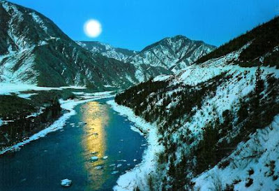
All these official cards from Russia are showing some beautiful landscapes of the Golden Mountains of Altai. These mountains are one of the many russian UNESCO sites since 1998. 

RU-5405484, sent by templar_phoenix.
The Altai mountains in southern Siberia form the major mountain range in the western Siberia biogeographic region and provide the source of its greatest rivers (...). 
The region represents the most complete sequence of altitudinal vegetation zones in central Siberia, from steppe, forest-steppe, mixed forest, subalpine vegetation to alpine vegetation. The site is also an important habitat for endangered animal species such as the snow leopard. - in: http://whc.unesco.org/en/list/768


 RU-345055, sent by Tanya.
"Katun is the main river at Altay and is famous for great rafting routes.
Katun is one of the major rivers at Altay, it's 688 km long and starts at the height of 2000 m at south Altay mountains, being fed by melting glaciers, smaller rivers, and Chuya river (along which passes Chuysky Trakt - the road to Mongolia).
From far, Katun looks like a green river, that is because there's a lot of limestone in the water, so the light is reflected in a strange way. Katun is not very wide: closer to Gorno-Altaysk it is just 20-30 meters wide and up towards the stream it may be 50 meters wide.
The stream in the river is quite strong, but it is possible to walk in at some places and swim a little bit, especially that the water during summer is not very cold. Katun is also great for fishing.
The main attraction of Katun is that for years, since the Soviet times, it has been a mecca for water tourism and rafting trips. Katun has a wide range of rapids of all kinds and complexities. It is a good place both for beginners and advanced rafters. There are a few annual rafting championships taking place at Katun." - in: http://www.waytorussia.net/Altay/Katun.html

RU-2761714, sent by Victoria.
Belukha is a twin-peaked mountain massif that rises along the border of Russia and Kazakhstan, just north of the point where these two borders meet those of China and Mongolia. There are several small glaciers on the mountain, including Belukha Glacier. Of the two peaks, the eastern peak (4,506 m, 14,784 ft.) is higher than the western peak (4,440 m, 14,567 ft.).
Belukha was first climbed in 1914 by the Tronov brothers. Most ascents of the eastern peak follow the same southern route as that taken in the first ascent. Though the Altai is lower in elevation than other Asian mountain groups, it is very remote, and much time and planning are required for its approach. - in: wikipedia

Agios Nikolaos tis Stegis Church - Cyprus

Last month Paulo surprised me again and an huge envelope full of cards that he got in a tourism fair and from a few other places. Most of the cards are from Portugal but there are a few from other countries too. 
The 1st of these cards was sent by him and the other by Luís. Both show the Church of Agios Nikolaos tis Stegis, one of the Painted Churches in the Troodos Region, classified as UNESCO WHS in 1985. 


The church of Agios Nikolaos tis Stegis (St. Nicholas of the Roof) is located in the Solea Valley (5km from Kakopetria village).
The domed cross-in-square church once belonged to a monastery complex and derives its name from its pitched timber roof that was built to protect it from the weather. It is the only surviving monastery church of its kind on the island and is covered entirely in wall paintings from the 11th to the 17th centuries, with the most important surviving set on the island from this period. As such, it is considered one of the most interesting Byzantine churches in Cyprus.

The church itself is dated to the 11th century, whilst the monastery dated to the end of the 13th or the beginning of the 14th century and flourished from the Middle Byzantine period up to the period of Frankish rule. It declined during the 18th century and ceased to function as a monastery by the end of the 19th century. - in: http://www.visitcyprus.com/index.php/en/discovercyprus/culture-religion/sites-monuments/item/259-agios-nikolaos-tis-stegis-church

Thursday, April 6, 2017

Archaeological Site of Ani - Turkey

This site is located on a secluded plateau of northeast Turkey overlooking a ravine that forms a natural border with Armenia. This medieval city combines residential, religious and military structures, characteristic of a medieval urbanism built up over the centuries by Christian and then Muslim dynasties. The city flourished in the 10th and 11th centuries CE when it became the capital of the medieval Armenian kingdom of the Bagratides and profited from control of one branch of the Silk Road. Later, under Byzantine, Seljuk and Georgian sovereignty, it maintained its status as an important crossroads for merchant caravans. The Mongol invasion and a devastating earthquake in 1319 marked the beginning of the city’s decline. The site presents a comprehensive overview of the evolution of medieval architecture through examples of almost all the different architectural innovations of the region between the 7th and 13th centuries. - in: http://whc.unesco.org/en/list/1518

This site was added to the WHS list in 2016 and the card was sent by Gökçe.

The church of St Gregory of Tigran Honents, finished in 1215, is the best-preserved monument at Ani. It was built during the rule of the Zakarids and was commissioned by the wealthy Armenian merchant Tigran Honents. Its plan is of a type called a domed hall. In front of its entrance are the ruins of a narthex and a small chapel that are from a slightly later period. The exterior of the church is spectacularly decorated. Ornate stone carvings of real and imaginary animals fill the spandrels between blind arcade that runs around all four sides of the church. The interior contains an important and unique series of frescoes cycles that depict two main themes. In the eastern third of the church is depicted the Life of Saint Gregory the Illuminator, in the middle third of the church is depicted the Life of Christ. Such extensive fresco cycles are rare features in Armenian architecture – it is believed that these ones were executed by Georgian artists, and the cycle also includes scenes from the life of St. Nino, who converted the Georgians to Christianity. In the narthex and its chapel survive fragmentary frescoes that are more Byzantine in style. - in: wikipedia

HU-122276

Getting an unexpected postcard from a missing UNESCO site is the ultimate and supreme joy of every UNESCO collectors. The Early Christian Necropolis of Pécs (Sopianae) was the only hungarian site I was still missing. Many, many thanks Éva.
The Early Christian Necropolis of Pécs (Sopianae) were added to the WHS list in 2000. 

Foto: Tám László
HU-122276, sent by Éva.
These are the ruins of a Late Roman Tomb Chapel.
Originally the entire building functioned as a burial chamber, however, it was rebuilt around 390 AD, when a stone altar was erected in its sanctuary, after which it was used exclusively as a chapel. Burials took place outside the building in tombs erected from stone or bricks. Over a hundred graves were uncovered during the excavation. Some of these can be viewed here, among them the grave of a mother with her child as well as a child's separate tomb. - in: http://www.iranypecs.hu/en/info/attractions/unesco-world-heritage/late-roman-tomb-chapel.html

Saturday, April 1, 2017

Eagle Owl

New Fauna of Belarus cards are always welcome and this one, sent by Karina, is really great.

Eurasian Eagle-owls combine fast and powerful flights with shallow wing beats and long, fast glides. They also soar on updrafts, displaying a type of flight similar to that of soaring hawks like the Red-tailed Hawk.
Eurasian Eagle-owls are among the world's largest owls.
Their pumpkin orange eyes and feathery ear tufts make them one of the most striking owls in the world.

Eurasian Eagle-owls are found throughout much of Europe and Asia and in parts of northern Africa. They live in a variety of wooded habitats. They are more commonly found in areas with rocky outcrops and cliffs, but they also live in open habitats that have some trees and rocky areas like taiga, farmlands, steppes, semi-arid areas, and grasslands.
Eurasian Eagle-owls are mostly nocturnal, or active at night. They spend their days roosting, or resting, in a safe perch. If they spend too much time on the ground, even these top predators may fall prey to opportunistic ground predators like foxes.
It is believed that these owls can live to be around 20 years old in the wild.
Eurasian Eagle-owls are not picky eaters. They mainly eat small mammals such as voles, rats, and rabbits but also hunt woodpeckers, herons, and other birds, including other raptors. They also prey on amphibians, reptiles, fish, and insects. - in: https://www.peregrinefund.org/explore-raptors-species/Eurasian_Eagle-owl