Monday, January 29, 2018

PL-1433058

Some interresting buildings and places in Rybnik, in southwestern Poland. 

Fot. Dariusz Krakowiak
PL-1433058, sent by Ola.
The building on the center of the card is St. Anthony Basilica, the largest church in Upper Silesia. 
The temple may look old but it was only built between 1903 and 1906.

UA-1620054

The beautiful former synagogue in Uzhhorod, a city located in western Ukraine, at the border with Slovakia and near the border with Hungary. It is the administrative center of Zakarpattia Oblast. 

UA-1620054, sent by Inna.
The synagogue was completed and dedicated on July 27, 1904, in a flamboyant Romantic style that boldly intermingled Byzantine Revival and Moorish Revival architectural elements.
Since World War II the building has served as Uzhgorod's concert hall, prized for its acoustics. It has housed the Regional Philharmonic Society with the Transcarpathian Folk Choir.
All Jewish symbols were removed from the building, although as of 2012 there is a plaque on the facade commemorating the 85,000 Jews from Zakarpattia Oblast who were murdered in The Holocaust. - in: wikipedia

Sunday, January 28, 2018

RU-6165579

An official card from Russia with a the Roman Fountain in the Lower Park of Peterhof Palace. 

Peterhof is one of the most visited former residences of Russian tsars which is mainly known for its beautiful park with several dozens of fountains and the baroque  Grand palace. 
The “trick fountains” of Peterhof can be a real delight for children as you can suddenly become poured over with water. The Grand palace and the fountains are situated in so called Upper and Lower gardens (in fact, the majority of them are in the Lower garden). - in: http://petersburgtrip.com/peterhof/

RU-6165579, sent by Kate.
The Lower Park (the Lower Gardens) is the centerpiece of the whole Peterhof ensemble. Its area stretches from the Great Palace to the Gulf of Finland. The fountains ensemble of the Lower Park is one of the largest in the world and includes about two hundred fountains. Most of them were constructed under Peter the Great. Numerous fountains and pavilions are scattered all over the park. - in: https://www.russiaeguide.com/peterhof.html

Friday, January 26, 2018

Nordkaap - Norway

Last year Ara has been twice to Norway, 1st to the Lofoten Islands and then a bit farther north at the Nordkapp. She sent a card with a matching stamp and postmark. The other card is an official that I got in 2011. 

Foto: Hurtigruten / Richard Pitcairn Knowles

Nordkapp (or North Cape in English) is located in Finnmark county, Norway.
North Cape rises a proud and mighty 308 meters above the Barents Sea. North Cape is the last point before the sea ice in the north.
Some 200,000 tourists visit this place annually, some to experience the midnight sun.

NO-48902, sent by Damla.
The midnight sun is a natural phenomenon which means that the sun does not set during the summer months. In other words, given fair weather, you can see the sun for a continuous 24 hours. The duration of the midnight sun depends on how far north you are and at the North Cape you can see the sun from 14 May to 29 July.

Thursday, January 25, 2018

Monfort Castle - France

A beautiful french castle card sent by Damien.

Chateau de Montfort is situated at Vitrac, (...) in the popular Dordogne region of south-west France. The Chateau de Montfort sits literally on a rocky ledge overhanging the cliffs, village and river below.

Photo: Gareth Kirkland
Montfort has had a turbulent history, starting with the renowned cathar, Bernard de Casnac, who lived in the chateau, and swore to 'cut into pieces all the catholics in the region'. But life was never simple for the cathars and Casnac soon attracted the attentions of Simon de Montfort, who succeded in seizing the castle and removing Casnac.
There is a popular legend at the chateau that the daughter of Casnac was burned to death at Montfort, and that her ghost still haunts the chateau.
The Château de Montfort has undergone a great deal of change, rebuilding and enlargement during the 800 years that it has been here, but still remains an imposing monument. - in: http://www.francethisway.com/places/chateaudemontfort.php

Pas de la Casa - Andorra

El Pas de la Casa is a ski resort (part of the Grandvalira resort), town, and mountain pass in the Encamp parish of Andorra, lying on the border with France. 
One of these card was bought by me in Andorra a few years ago and the other two were sent by Heidi and Carla. 

Its name literally translates as "the pass of the house" and refers to the fact that until the early twentieth century there was only a single shepherd's hut overlooking the pass. The pass marks the watershed of the Pyrenees, being the only point in Andorra where water drains into the Atlantic Ocean, and is the source of the Ariège river.

 At an elevation of 2,408 metres (7,900 ft) it is one of the highest points on the European road network.
The two main sources of wealth are trade, which generates a border tourism, especially people from France through its warehouses without taxes and winter sports, with the ski slopes of Grandvalira.

The ski resort of Pas de la Casa sits below the pass on the side closest to France, and below the Pic d'Envalira (2,827 metres (9,275 ft)). Its first ski lift was opened in 1957 and it now has 31 lifts, 100 kilometres (62 mi) of pistes and 6.26 square kilometres (2 sq mi) of skiable terrain.
Grau Roig is a sector of the Grandvalira ski resort in Andorra, located in the parish of Encamp. It includes alpine skiing and cross-country skiing tracks. It is the only sector in Grandvalira which does not have a populated settlement. - in: wikipedia

Antequera Dolmens - Spain

The 1st card from a new UNESCO site came from Spain, sent by Jordi.
In 2016 Antequera dolmens, along with two mountains closely connected to the dolmen complex, were declared UNESCO World Heritage. These dolmens are the seventh WHS in Andalucia.
Just outside Antequera you can visit three 5000-year-old dolmens: Menga Dolmen, shown on the card, and Viera Dolmen, both located just outside the town. El Romeral Dolmen is a few km away.
The Menga and Viera dolmens were probably built between 3500 and 3000BC, while El Romeral was constructed later - in about 2500BC.

Foto: Xavier Durán
Menga Dolmen in the largest in Europe at nearly 30m long. The largest upright stone weighs 180 tonnes. By way of comparison, the heaviest stone at Stonehenge, in Wiltshire in the UK, weighs 40 tonnes.
The Menga Dolmen tomb comprises three different sections. The first is an open corridor or atrium porch section that would have been partially or completely unroofed, leading to a passage or corridor section of four stones. These oversized entrance 'capstones' have become the iconic image of the Menga Dolmen. This passage leads to the large oval-shaped funerary chamber.
This dolmen was built using the 'orthostatic technique', which means constructing a wall from 'planting' large upright stones called orthostats and laying across horizontal capstones to form a roof. It is 27.5m long, while the height gradually increases from 2.7m at the entrance to 3.5m at the far end. The widest point is 6m towards the back, with a floor shaft 1.5m in diameter and 19.5m deep. The shaft is aligned with three pillars that support four enormous 250-tonne roof stones.
Each side is made of 12 upright stones and one stone closing the far end. The roof is made of five stones; a sixth that was placed over the entrance is missing. The tomb is covered by a 50m-diameter tumulus of stones and soil. 
The Menga Dolmen is famous for its significant geographical location - on the summer solstice, 21 June, the morning sun shines over the peak of the Peña de los Enamorados and straight along the dolmen's entrance corridor. This very exact positioning would have held mystical importance for the prehistoric tribes who built the dolmen thousands of years ago. - in: http://www.andalucia.com/antequera/dolmens-de-menga.htm

Wednesday, January 17, 2018

DE-6775018

The ID of this card is german but the card is spanish, no doubts about that. These are some of the most famous landmarks in Madrid.

www.ediciones07.com
DE-6775018, sent by Nikolai.
* The Cybele Palace, formerly the Palace of Communication until 2011, is a palace located on the Plaza de Cibeles. Currently the seat of the City Council, it opened in 1919 as the headquarters of Correos, the Spanish postal and telecommunications service;
* Royal Palace, the largest royal palace in Western Europe;
* Puerta del Sol, the symbolic centre of Madrid, where the city’s main streets meet:
* Las Ventas Bullring, the most famous bullfighting ring in the world is a beautiful Neo-Mudéjar building, where every bullfighter dreams of glory;
* Gran Vía is an ornate and upscale shopping street located in central Madrid. Today the street is known as the Spanish Broadway, and it is one of the streets with the most nightlife in Europe. It is known as the street that never sleeps. It leads from Calle de Alcalá, close to Plaza de Cibeles, to Plaza de España.

Ponteareas - Spain

Ponteareas is town in the province of Pontevedra, in Spain. Vanesa lived here before moving to her new address some time ago. 
It was with this card that he wished me an happy new year. 

© Ediciones Paris 2
This bridge is known as Roman bridge although it has medieval origins.

Toledo - Portugal

One more lady for my elderlies collection. Thanks Leninha. 

Photography & design: Dadifoto - Actividades Fotográficas Lda
I had no idea there was a place in Portugal called Toledo. I don't know where it is located but it must be near the Vimeiro War Interpretation Center where Leninha bought this card. 

Monday, January 15, 2018

Winner of the Month - January 18

This month Patrícia was the winner of this game but she thought it was me and sent me this card. 

Fotógrafo: Nuno Felix da Costa © 2002 Edições 19 de Abril
There's not much to say about this card. The picture was taken somewhere in Trás-os-Montes region, northern Portugal, in 1980. 

8th Christmas Meeting - Portugal

Last year, the portuguese Christmas meeting happed exactly one month before Christmas. On November 25th, some of the usual suspects, some new faces and two international postcrossers, gathered in Viana do Castelo.
As for the postcards, they were sent by Zé and Vanesa, Sofia, Inês and Tiago. Ninocas also sent me this card of Lagarteira Fort but I already had it.

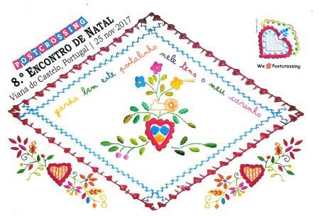
desenho da autoria de Tiago Parreira
Tiago got inspired by the valentine's handkerchiefs and and created a special card for this meeting.
Valentine's handkerchief is an handkerchief made from a fine linen cloth or cotton cloth, embroidered with various motifs. It is a piece of handicraft and clothing typical of Minho region, being used by women of marriageable age.
In the old days, a girl in love embroidered her handkerchief and hand it over to the boy she loved when he went away. The handkerchiefs could have embroidered verses, in addition to several designs, some standardized, having their own symbologies.
It was used as a ritual of conquest. Once made, the handkerchief would eventually come to the possession of the beloved man, who would use it in public as a way of showing that he had begun a relationship. If the boy did not use the handkerchief in public, it was a sign that he had decided not to initiate the relationship. 

www.modernistica.pt
 Sofia sent this illustrated version of the typical costumes in Minho region.

www.modernistica.pt
Speaking of which, the bride costume is one of the emblematic and beautiful costumes of Minho. 
The black fabric gives the whole costume the solemnity required of the very ritual of marriage or the few exceptional occasions in which it was worn. To mark these moments, the girl placed all the gold she had on her chest, thus showing her economic power. Ambiened by all the young girls in Minho, this costume was  object of the greatest care and stored in the ark, after the rare apparitions in public, to one day be given to the daughter or the granddaughter, as if it was a jewel. Sometimes this costume was wore, one last time, as a shroud.

Grupo MJF
The Cathedral of Viana, although it has a massive Romanesque like structure, is undoubtedly a work influenced by gothic aesthetic, and its construction began in the beginning of fifteenth century. 

Monday, January 8, 2018

Poço da Ribeira do Ferreiro, Flores Island - Portugal

A Jurassik Park like landscape!! No dinossaurs here though, only the beauty of nature. 
Ribeira do Ferreiro Lagoon, also known as Alagoinha, is located in the parish of Fajã Grande. 

It is one of the most beautiful places of the Island of Flores, and therefore the visit is mandatory. In this small paradise where vegetation will surround you, there is a small lagoon fed by 20 breathtaking waterfalls falling from the cliffs. 

© Fotografia: www.aerografica.pt
Trully amazing and definitely on my must visit list. Lurdes also sent me this 2nd card and I bought the 1st on São Miguel island. 

Flores Island - Portugal

Flores Island  is an island of the Western group of the portuguese archilepago of the Azores. Although Lurdes lives now on Terceira island, she was born on Flores, the most beautiful of the Azores islands, she says. 

© Fotografia: www.aerografica.pt
 Fajã Grande, occupying an area of approximately 12.55 square kilometers, is one of the most populated parishes of the municipality of Lajes das Flores. 
About 2 kilometres north of Fajã Grande you’ll find the small village of Ponta da Fajã, its origin to be traced back until 16th century. 

© Fotografia: www.aerografica.pt
 Alagoa Bay, located near an uninhabited settlement, it is a natural extension of the Ribeira da Alagoa, the ravine and valley that divides the coast.
Natural Reserve of the Islets of Alagoa Bay and Baixa do Moinho is a site of communitarian interest, that includes an area of 100 meters around the islets of Alagoa, for the protection of marine flora and fauna, and especially for population of Roseate and Common terns. - in: https://www.geocaching.com/geocache/GC32C28_baia-da-alagoa-flores-acores

© Fotografia: www.aerografica.pt
 The Monchique Islet is a small islet, west of the village of Fajã Grande, off the coast of the island of Flores, in the western part of the Portuguese archipelago of the Azores. It is the westernmost point of Portugal and if considered part of Europe (although it sits on the North American Plate) it would be its westernmost point as well.
Historically, it functioned as an astronomical (celestial) navigational guide and reference mark for mariners, who calibrated their navigational equipment by referencing the islet on long Atlantic crossings. - in: wikipedia

© Fotografia: www.aerografica.pt
The Ribeira das Casas stream is located in the municipality of Santa Cruz das Flores. It's spring is located in an altitude of about 800 meters, in the foothills of  Burrinha Peak It empties into the Atlantic Ocean near the Ponta do Baixio, from the top of a cliff with about 500 meters high.

© Fotografia: www.aerografica.pt
These lagoons, White, Black, Long and Dry, are 4 of the 7 lagoons located in the Flores Caldera.

Thursday, January 4, 2018

Europe RR - Group 53 * Castles

This was the 1st time I joined this RR and decided to take part in 2 groups, castles and churches. The churches group is still not complete.
The castles group was a group with 5 persons from 5 different countries, each one of us was supposed to get 4 cards but only 3 arrived to our mailboxes.

Susi from Austria sent this card with a water castle in Kottingbrunn. Couldn't find much information about the castle. 

© MS AGENCY
From Slovakia a card with Bratislava castle sent by Laco. 
Bratislava Castle, the landmark overlooking the Capital, was built in the 9th century. As an agelong symbol of the city, it proudly stands on the hill above Danube river. Eleven kings and eight queens were crowned in Bratislava in the past. - in: http://www.slovakia.com/castles/bratislava-castle/

© Schöning GmbH & Co. KG
I believe this is my 1st card from Hanau, a town located 25 km east of Frankfurt. 
One of the most beautiful places in Hanau is the Baroque palace of the XVIII century Philippsruhe Palace off the coast of the Main river. The castle, the construction of which began in 1700, served as the summer residence for Count Philipp Reinhard of Hanau. Over time an extensive park was created around the palace with an orangery and a tea house and the building was significantly expanded. Today Philippsruhe houses the history museum. - in: https://tourism.restaurantsworld.com/germany/place/philippsruhe-palace/
The card was sent by Svea. 

Kilauea - USA

Volcanoes are dangerous but beautiful at the same time. Well, is easy to say this because there's no active volcanoes nearby!!

Kilauea is one of the world’s most active volcanoes. It is a shield-type volcano that makes up the southeastern side of the Big Island of Hawaii.

 The volcano rises 4,190 feet (1,227 meters) above sea level and is about 14 percent of the land area of the Big Island. The summit caldera contains a lava lake known as Halema`uma`u that is said to be the home of the Hawaiian volcano goddess, Pele.
To the casual observer, Kilauea appears to be part of the larger volcano Mauna Loa, but geological data indicates that it is a separate volcano with its own vent and conduit system. Kilauea has had 61 recorded eruptions in the current cycle, according to the U.S. Geological Survey, and has been erupting on a continuous basis since 1983.

 © mauritius images / Photo resource
DE-3961332, sent by Lisa.
The long-lasting eruption has destroyed more than 200 structures, including the Hawai`i Volcanoes National Park visitor center, the Royal Gardens subdivision and many homes and buildings in the town of Kalapana. For the last few years, lava from Pu`O O`O crater mostly streamed south toward the ocean. But on June 27, 2014, flow erupted from a vent on the northeast flank of the crater. - in: http://www.livescience.com/27622-kilauea.html