Showing posts with label Philippines. Show all posts

Thursday, October 31, 2024

Baracay Island - Philippines

Over the years I've received many cards sent by Marie, most of them from Canada, where she lives, but this one is from her home country, the Philippines. 

Boracay is the most iconic island in the Philippines.
The tranquil waters and famous white sands of Boracay are the main reasons why this tiny island in the Philippines’ Western Visayas region is a paradise getaway for both tourists and locals.

 by Carlos Jurew
A traditional Paraw ride is a unique way to explore Boracay’s waters. These double outrigger sailboats offer a serene experience, especially at sunset. 
The Paraw (also known as parao) is a traditional outrigger sailing boat from the Philippines. Locals believed the first boats were adopted from Borneo and Malay traders who frequently visited the Philippines.
Paraws are made with wood and bamboo. They come in different sizes and shapes, but the most common form is the double outrigger. It is a configuration that gives more stability and increased seating capacity.
Traditionally, paraw sailboats are mainly used for fishing and inter-island travel. However, today, paraws are commonly used for recreational trips such as island hopping and sunset tours. - in:
https://happinessontheway.com

Tuesday, February 11, 2020

Monthly Fav. Surprise RR - January 20

I didn't join this RR in December, way too much mail to send that month, but last month I joined again. January's cards arrived from Austria, Philippines, Taiwan and Belarus. 

www.papersisters.de
Yay, Marienne sent me a new card to my still small Happy Postcrossing from collection. Thank you so much.
On the card stand out two famous Austrians, Mozart and Freud. When it comes to food, some of the most famous specialities are Kaiserschmarrn, a sweet dessert, Sacher Torte and Wiener schnitzel. 
Other things worth to mention are the Clock Tower of Graz, Hohensalzburg Fortress in Salzburg, Lake Neusiedl and Lipizzaner horses.

The Philippines is an archipelago of over 7,000 islands. Guyam Island is one of the three islands located in the Surfing Capital of the Philippines, Siargao.
It is an islet that has a small stretch of powdery-white sand and dotted with coconut trees. It also has interesting coral rock formations that are perfect for snorkeling. The rest of the island (facing the Pacific) is battered with rocks. A few meters away from the island, tourists can enjoy surfing and swimming. - in: https://www.vigattintourism.com
The card was sent by Aiden. 

Surrounded by sea on four sides, Taiwan has a total of 36 lighthouses in different shapes. Keelung Lighthouse is located on the top of a hill near the Port of Keelung in northern Taiwan. 
Card sent by Chi. 

Tanya sent me my erd card of the the Corpus Christi Church in Nesvizh. It is part of the Architectural, Residential and Cultural Complex of the Radziwill Family at Nesvizh, an Unesco World Heritage Site. 

Tuesday, May 15, 2018

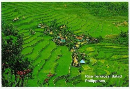
Rice Terraces - Philippines

The Rice Terraces of the Philippine Cordilleras is an outstanding example of an evolved, living cultural landscape that can be traced as far back as two millennia ago in the pre-colonial Philippines. The terraces are located in the remote areas of the Philippine Cordillera mountain range on the northern island of Luzon. The inscribed property consists of five clusters of the most intact and impressive terraces, located in four municipalities. Batad is one of the five inscribed clusters. 
Contrary to popular belief, the Banaue Rice Terraces are not a UNESCO World Heritage Site. They were not included in the UNESCO inscription Rice Terraces of the Philippine Cordilleras due to the presence of numerous modern structures. 

PH-126869, sent by Gladdie.
The Banaue Rice Terraces are a National Cultural Treasure of the Philippines and are considered to be the 8th Natural Wonder of the World by many Filipinos.
The terraces are carved in the mountains of Ifugao and were most likely done by hand. The terraces were first constructed as a practical solution to the problem of growing rice on land that falls away in front of you at vertigo-inducing angles. 
The rice terraces here were declared in 2009 free from any genetically modified organisms. Farming in the area is carried out much the same way it was carried out hundreds of years ago.
The terraces can be visited anytime of the year but the best time for a visit is between February and March when the cleaning and planting time occurs and between June and July when the harvest occurs. - in: http://www.banaueterraces.com/

Batad is a remote village of around 1,500 people in Ifugao province. It’s said to be home to the best and most well-preserved rice terraces in the Cordillera region. These terraces are between 2,000-6,000 years old and have been a UNESCO World Heritage Site since 1995.
The Batad rice terraces clusters are considered an engineering marvel and a rare man-made landscape because of its amphitheater-like form and almost vertical ponds. 

Monday, January 1, 2018

PH-121817

If I counted correctly, in 2017 I've sent 96 official cards and received 92. One of the received was this one from the Philippines, only my 3rd official from there. 

St. Paul's Cathedral is a Roman Catholic cathedral in Vigan. It is part of the UNESCO World Heritage Site  Historic Town of Vigan, added to the WHS list in 1999.

Photographer: Roland Weiss
PH-121817, sent by Susan.
The St. Paul’s Cathedral, also known as the metropolitan Cathedral, is considered a major religious landmark not only of northern Luzon but the country as well. Visitors must include a visit to the cathedral when in Vigan as it has been a center of Roman Catholic devotion for centuries. The church as it stands now was completed in 1800. The original structure was built in 1574 upon the command of the Spanish founder of Vigan, Juan de Salcedo. It was a mere chapel then, made of wood and thatch. In 1641, the chapel was replaced by a church.
When the seat of the Nueva Segovia Diocese was transferred to Villa Fernandina de Vigan from Cagayan’s Lal-lo in 1758, the church was elevated to the status of a cathedral and became the center of Catholic faith in the north. Another structure was ordered by then Governor Jose de Basco to be built to replace the existing church in 1786. With the Augustinians, the cornerstone of the new church was laid in the beginning of 1790.
Overall, the cathedral follows a Baroque architectural design that has been modified by Ilocanos to strengthen the structure against earthquakes. This is now known as earthquake Baroque. Testament to the style’s effectivity is the fact that the structure’s original interior walls have remained complete.
Other influences can be observed from the architecture of St. Paul Cathedral, that of neo-Gothic, pseudo-Romanesque and Chinese craftsmanship. Facing the cathedral, visitors are greeted by the statue of St. Paul above the main opening. - in: https://www.vigan.ph/heritage/st-pauls-cathedral.html

Wednesday, February 1, 2017

Mount Hamiguitan Range Wildlife Sanctuary - Philippines

I had once cards from all the Philippines UNESCO sites but in 2014 Mount Hamiguitan Range Wildlife Sanctuary was added to the WHS list and I had to wait 2 years to get a card from there. I got it thanks to Jan. 

Photos by Boj Capati
Forming a mountain ridge running north-south along the Pujada Peninsula in the south-eastern part of the Eastern Mindanao Biodiversity Corridor, the Mount Hamiguitan Range Wildlife Sanctuary has an elevation range of 75–1,637 m above sea level and provides critical habitat for a range of plant and animal species. The property showcases terrestrial and aquatic habitats at different elevations, and includes threatened and endemic flora and fauna species, eight of which are found only at Mount Hamiguitan. These include critically endangered trees, plants and the iconic Philippine eagle and Philippine cockatoo. - in: http://whc.unesco.org/en/list/1403

Saturday, August 3, 2013

Mt. Pulag National Park - Philippines

I'm still not very focused on the UNESCO Tentative list but i've been receiving a few tentative sites in the last weeks. 
Jan, wanted one of my Lisbon's cards and in returned i picked this Mt. Pulag card. This national park is on the tentative list since 2006. 

© Philippine Copyright 2010
Published and Exclusively Distributed by National Book Store
The whole park is located within the Philippine Cordillera Mountain Range and is very rugged, characterized by steep to very steep slopes at the mountainsides and generally rolling areas at the mountain peak. Mt. Pulag National Park is the highest peak in Luzon and is the second highest mountain in the Philippines with an elevation of 2,922 m. above sea level.
The summit of Mt. Pulag is covered with grass and dwarf bamboo plants. At lower elevations, the mountainside has a mossy forest veiled with fog, and full of ferns, lichens and moss. Below this is the pine forest growing on barren, rocky slopes. Falls, rivers and small lakes mark the area.
The Park has a large diversity of flora and fauna, many of which are endemic to the mountain. Its wildlife includes threatened mammals such as the Philippine Brown Deer, Northern Luzon Giant Cloud Rat and the Luzon Pygmy Fruit Bat.  One can also find several orchid species some of which are possibly endemic to Mt. Pulag, and other rare flora such as the pitcher plant.

Mt. Pulag is an important watershed providing the water necessities of many stakeholders for domestic and industrial use, irrigation, hydroelectric power production and aquaculture. - in: http://whc.unesco.org/en/tentativelists/5030/

Friday, January 25, 2013

PH-45496

In 6 years of postcrossing this is my 2nd official from the Philippines. I love it, this church is really beautiful. The card was one of my favorites.

Photo by Donald C. Tapan
PH-45496, sent by Cayl.
The Miag-ao Church was built in 1786 by Spanish Augustinian missionaries and was declared as part of the UNESCO World Heritage Site "Baroque Churches of the Philippines" in 1993.
On the front facade, which is flanked by two watchtower belfries, one can see the unique blending of Spanish and native influences.
The central feature of the bas-relief facade is a large coconut tree which reaches almost to the apex. While an integral part of the Philippine landscape, the coconut tree is also the subject of lore. According to an old Philippine legend, the coconut tree was the only bequest from a loving mother to her two children, a tree which sustained them for life. On the church's facade the coconut tree appears as the "tree of life" to which St. Christopher carrying the Child Jesus on his shoulder is clinging to. The lesser facades feature the daily life of Miagaowanons during the time. Also depicted are other native flora and fauna, as well as native dress.
The church and its watchtowers were also built to defend the town and its people against raids by the Moros. It therefore has thick walls and, reportedly, secret passages. Indeed stretching along the Iloilo coast are defensive towers, but none that equal the size of the Miag-ao. It is because of this defensive purpose that it is sometimes referred to as the Miag-ao Fortress Church. - in: wikipedia

Wednesday, January 5, 2011

Tubbataha Reef - Philippines

The Tubbataha Reef was the last unesco card of 2010 and with this card sent by Jan "janbonivic", i've all the unesco sites from the Philippines.
Tubbataha Reef is an atoll coral reef located in the Sulu Sea of the Philippines. It is a marine sanctuary protected as Tubbataha Reef National Marine Park. It was declared as a Unesco World Heritage site in 1993.


"The Tubbataha Reef Marine Park covers 130,028 ha, including the North and South Reefs. It is a unique example of an atoll reef with a very high density of marine species; the North Islet serving as a nesting site for birds and marine turtles. The site is an excellent example of a pristine coral reef with a spectacular 100-m perpendicular wall, extensive lagoons and two coral islands." - in: www.whc.unesco.org/en/list/653

Thursday, October 7, 2010

Philippine cards

Thanks to my unwanted cards i've received these 2 from the Philippines sent by Mary Anne "presea".

"El Nido is a first class municipality and managed resource protected area in the province of Palawan in the Philippines.
It is composed of 45 islands and islets, each has its own unique geological formations.
From the towering marble cliffs and enchanting lagoons to its 100 white sandy beaches and lush jungle, El Nido is one of the top tourist destinations in Palawan, which is often referred to as the Philippines' Last Frontier. In the November-December 2007 issue of the National Geographic Traveler's magazine, Palawan was chosen as one of the best travel destinations in the world, and particularly, it recommended El Nido and the Calamianes Inlands." - in: wikipedia

"Basilica de San Martin de Tours in Taal is the largest church in Asia, standing 96 meters long and 45 meters wide. The Augustinian Missionaries started construction in 1756, but it was destroyed when Taal Volcano erupted in 1754. Today only the ruins of the walls of the original church is now left standing. It took a century for the church to achieve its present form." - in: wikipédia

Thursday, February 11, 2010

US & PH

When i got home from Switzerland, I had a couple of cards waiting for me, some of them were officials. These 2 are from the USA and the Philippines.

US-599151, sent by Jeanne.
On the back of the card: "Beautiful Puget Sound, in scenic Washington State, is an arm of the vas Pacific Ocean. The Sound is nestled between the glacied Olympic Mountains to the west and the spectacular Cascade Range to the east. The crown of Washington, Mount Rainier is only 40 miles from sea level at Tacoma. The now famous and eruptive Mt. St. Helens is 70 miles south of Tacoma and 90 miles south of Seatle. Numerous interesting state ferry routes ply Puget Sound."

PH-13848, sent by Pearl.
I think this is my 1st official from the Philippines.
This card was made by Pearl and the pictures were take by one of her friends.

Friday, January 15, 2010

November RR - XI

I thought i was not going to receive more cards related with this RR but yesterday arrived this card from the Philippines. It was sent by Marian "upto6only".

"The Chocolate Hills are an unusual geological formation in Bohol, Philippines. According to the latest accurate survey done, there are 1,776 hills spread over an area of more than 50 square kilometres (20 sq mi). They are covered in green grass that turns brown during the dry season, hence the name.

The Chocolate Hills are a famous tourist attraction of Bohol. They are featured in the provincial flag and seal to symbolize the abundance of natural attractions in the province. They are in the Philippine Tourism Authority's list of tourist destinations in the Philippines; they have been declared the country's 3rd National Geological Monument and proposed for inclusion in the UNESCO World Heritage list." - in: wikipedia

Friday, October 30, 2009

Puerto Princesa Subterranean River

I got this card from the Philippines today, it's a new unesco card from there. Now, only one is missing to have all the unesco sites from the Philippines.
The card was sent by Jan "janbonivic".

"The Puerto Princesa Subterranean River National Park is located about 50 kilometers north of the city of Puerto Princesa, Palawan, Philippines. The National Park is located in the Saint Paul Mountain Range on the northern coast of the island. It is bordered by St. Paul Bay to the north and the Babuyan River to the east. The entrance to the Subterranean River is a short hike from the town of Sabang. Puerto Princesa Subterranean River National Park has been nominated for the "New Seven Wonders of Nature" competition.
The park has a limestone karst mountain landscape with an 8.2 kilometer navigable underground river. A distinguishing feature of the river is that it winds through a cave before flowing directly into the South China Sea. It includes major formations of stalactites and stalagmites, and several large chambers. The lower portion of the river is subject to tidal influences. Until the 2007 discovery of an underground river in Mexico's Yucatan Peninsula, the Puerto Princesa Subterranean River was reputed to be the world's longest underground river.
The area also represents a habitat for biodiversity conservation. The site contains a full mountain-to-the-sea ecosystem and has some of the most important forests in Asia. It was inscribed by UNESCO as a World Heritage Site in 1999." - in: wikipedia

Monday, December 29, 2008

Unesco WHS from Philippines

These are my 1st unesco cards from the Philippines. Many thanks to Ritzval "ritz".


"The Paoay Church is included in the Unesco World Heritage list.
Construction of the church started in 1704 and was completed in 1894. It is probably the best-known “earthquake Baroque” church in the Philippines. Large coral stones were used for the lower level while bricks were used for the upper levels of the church. The walls are 1.67 meters thick and are supported by 24 carved and massive buttresses.
The Church is a unique combination of Gothic, Baroque and Oriental designs.The bell tower near the church, dating from 1793, served as an observation point of the “Katipuneros” during the Philippine Revolution in 1896 and again by the guerrillas during the Japanese occupation." - in
: http://www.pinoytravelblog.com/roadtrip/334/paoay-church-paoay-ilocos-norte

"Established in the 16th century, Vigan is the best-preserved example of a planned Spanish colonial town in Asia. Its architecture reflects the coming together of cultural elements from elsewhere in the Philippines, from China and from Europe, resulting in a culture and townscape that have no parallel anywhere in East and South-East Asia.
Justification for Inscription
Vigan represents a unique fusion of Asian building design and construction with European colonial architecture and planning. Vigan is an exceptionally intact and well preserved example of a European trading town in East and South-East Asia." - in:
http://whc.unesco.org/en/list/502

Wednesday, March 19, 2008

Manila - Philippines

"The City of Manila is the capital of the Philippines and one of the cities that make up the greater metropolitan area of Metro Manila. Manila is the center of government in the country and one of the central hubs of a thriving metropolitan area home to over 14 million people." - in: wikipedia.
The card was sent by Marie "renegade_cavalcade".

Saturday, December 15, 2007

Volcanos

"Mayon Volcano is an active volcano in the Philippines on the island of Luzon, in the province of Albay in the Bicol Region. Its almost perfectly-shaped cone is considered by some to be the Philippine equivalent of Mount Fuji in Japan.
Mayon Volcano rises 2462 m (8,077 ft) above the gulf of Albay. Mayon Volcano is the Philippines' most active volcano and considered as the world's most perfectly formed volcano for its symmetrical cone.
The most destructive eruption of Mayon occurred on February 1, 1814. Lava flowed but not as much compared to the 1766 eruption. Instead, the volcano was belching dark ashe and eventually bombarding the town with tephra that buried the town of Cagsawa—only the bell tower of the town's church remained above the new surface. Trees were burned; rivers were certainly damaged. Proximate areas was also devastated by the eruption with ash accumulating to 9 m (30 ft) in depth. 2,200 Albay natives perished in what is considered as the most lethal eruption in Mayon's history." - in wikipedia.
This card was sent by Jane "enajpostcards".

"Krakatoa or Krakatau or Krakatao is a volcanic island in the Sunda Strait between Java and Sumatra in Indonesia. The name is used for the island group, the main island (also called Rakata), and the volcano as a whole. It has erupted repeatedly, massively, and with disastrous consequences throughout recorded history. The best known eruption culminated in a series of massive explosions on August 26-27 1883.
The 1883 eruption ejected more than 25 cubic kilometres of rock, ash, and pumice, and generated the loudest sound historically reported: the cataclysmic explosion was distinctly heard as far away as Perth in Australia approx. 1,930 miles (3,110 km), and the island of Rodrigues near Mauritius approx. 3,000 miles (5,000 km). Near Krakatoa, according to official records, 165 villages and towns were destroyed and 132 seriously damaged, at least 36,417 (official toll) people died, and many thousands were injured by the eruption, mostly from the tsunamis which followed the explosion.
The eruption destroyed two thirds of the island of Krakatoa. Eruptions at the volcano since 1927 have built a new island in the same location, called Anak Krakatau (child of Krakatoa)." -
in wikipedia.
The card was sent by "jetske".

Wednesday, August 8, 2007

RAS card - Philippines

This was my 6th RAS card and it was sent by Marie "Renegade_cavalcade" while she was on vacation in the Philippines.

"Tarsier, the world's smallest primate * Chocolate Hills * Corella tropical beaches of Panglao Island * Punta Cruz Watch Tower, built by Spaniards to look out for pirates, represents one of many Spanish heritage found in Bohol * Underwater reefs of Balicasag Island are one of the world's best * Mag - Aso Falls set in tropical forest of Bohol."