Friday, August 29, 2025

Xixia Imperial Tombs - China

 China has also added a new site to its already long list of sites classified as World Heritage. By long list I mean 60 sites, making it the 2nd country with the most UNESCO sites. I'm only missing one site.

Xixia Imperial Tombs are located in the foothills of the southern Helan Mountains in Ningxia, this necropolis is the imperial cemetery of the Xixia Dynasty.

It includes nine imperial mausoleums, 271 subordinate tombs, a northern architectural complex, and 32 flood control structures. Founded by the Tanguts in 1038, the Xixia Dynasty lasted until its destruction by Genghis Khan’s Mongol army in 1227. Positioned along the Silk Road, it became a multicultural civilization modelled on Chinese imperial traditions, with Buddhism at its core. The property reflects the dynasty’s religious and socio-political legacy. - in: https://whc.unesco.org

Pratapgad Fort - India

Pratapgad Fort is one of the 12 mountain forts in India, classified this year as UNESCO WHS. It didn't take me too long to get my 1st card of this new site. It was sent by Sriram. 
Maratha Military Landscapes of India includes twelve major fortifications, mostly in Maharashtra State, with one in Tamil Nadu. These forts (...) were built, adapted, or expanded by the Marathas between the late 17th and early 19th centuries. Strategically located on coastal and mountainous terrain, they formed a complex defence system supporting Maratha military dominance, trade protection, and territorial control. This network played a key role in the Marathas’ rise as a major political and military force. - in: https://whc.unesco.org

The pride of the Maratha Empire, the Pratapgarh Fort is a historical monument (..) perched in Satara district and at an altitude of 3500 feet above ground level, the Pratapgarh Fort was built by Maratha King – Chhatrapati Shivaji Maharaj in 1656 to guard the Par Pass.
Three years later, a major fight between the General of Bilaspur - Afzal Khan, and Shivaji happened here. Shivaji emerged as the winner at that time of the battle. However, in 1818, after losing the 3rd Anglo-Maratha war, the Marathas had to surrender it to the English East India Company. - in:
https://mahabaleshwartourism.in

Thursday, August 21, 2025

Stonehenge - England

 Stonehenge is a prehistoric monument located in the English county of Wiltshire. It is one of the most famous sites in the world and it was classified as UNESCO WHS in In 1986. Together with Avebury, it was one of the very first sites in the UK to be made a UNESCO World Heritage Site.
 
Work began on Stonehenge about 5,000 years ago, but it was built in stages over many years. The stone circle dates from about 2500 BC, in the late Neolithic period.
We don’t know exactly how the stones were brought to Stonehenge, but some of them – the bluestones – came from the Preseli Hills in south-west Wales, over 150 miles (250km) away.
We can only speculate as to what Stonehenge’s purpose was. But the fact that the sun rises over the Heel Stone on the longest day of the year (summer solstice) and sets over it on the shortest day (winter solstice) suggests that it was a prehistoric temple aligned with the sun’s movements.

US-11556461, sent by Charlene.
 Stonehenge’s builders raised the stones using joints normally found only in woodworking, and not seen at any other prehistoric monument. This makes it the most architecturally sophisticated surviving stone circle in the world.
Far from standing alone, Stonehenge forms part of a remarkable complex of connected prehistoric sites across the Wiltshire landscape. - in:
https://www.english-heritage.org

NL-6022442

 I had to use google images again to identify this lighthouse and its location. The card is an official from the Netherlands but the lighthouse is located in Germany. 
 
Photo: Dirk Petersen
NL-6022442, sent by Esther.
The vibrant green Westmole lighthouse is located in Warnemünde, Germany. The lighthouse stands at the end of a stone mole, overlooking the Baltic Sea. 

FR-1816640

I've never heard about the Queyras before getting this card. This is a valley, also one of the 58 French Regional nature parks,  located in the Hautes-Alpes department in Southeastern France. 
The Queyras is one of the oldest mountain ranges of the Alps, and it was one of the last ones to be opened to public tourism towards the end of the 20th century, thus being relatively untouched by environmental destruction. 
For he hiking enthusiasts, it offers a multitude of trails to explore. One of the most popular hiking trails is the the Lacs du Malrif.
 
Photo: J. Sierpinski
FR-1816640, sent by Myriam.
The Malrif Lakes are a series of three glacial lakes located within a few hundred meters of each other. 
This 12-kilometer, 6-hour-30-minute hike begins in Aiguilles, offering breathtaking views of the lakes nestled between the mountains and lush meadows. 
The lake on the card is the Grand Laus lake, located at an altitude of 2,579 metres. It is the largest of the 3 lakes. 

Saturday, August 16, 2025

Étretat - France

Normandy is one of the regions I'd like to visit in France and if I ever get to visit it, I'll definitely see the Étretat cliffs. Raquel has veen there and she sent me the 1st of these cards back in 2012. The other one is an official from Germany, received a few days ago.

Étretat is located in the Seine-Maritime department in the Haute-Normandie region in northern France.
Étretat is best known for its cliffs, including 3 natural arches and the pointed "needle".

 Photo by F. Godard
Formed millions of years ago beneath a sea that covered Normandy, the cliffs of Etretat are the result of the accumulation of limestone and flint by marine organisms, then raised by tectonic movements. Erosion by waves, wind and frost has sculpted the arches and needles we see today. The whiteness of the cliffs comes from the limestone, while the black bands are made of flint, once used to make fire. - in: https://cparici.com
 
Huber Images / Kamel
 DE-15634166, sent by Caro.
The Porte d’Aval (on the left when looking at the sea), a huge flint archway, was carved by the waves beating the end of the Falaise d’Aval. The 51-metre-high needle bears witness to the geological past of the cliffs of Etretat. It has become famous, gained a universal reputation and inspired many painters and writers. Is it hollow and did it shelter the treasure of the Kings of France discovered by Arsène Lupin, as recounted in Maurice Leblanc’s novel, L’aiguille Creuse. You can find out more about this enigma by visiting Le Clos Lupin, the property acquired by the novelist in 1919. - in: https://www.lehavre-etretat-tourisme.com

Saturday, August 9, 2025

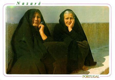
Nazaré's widow costume - Portugal

Paula and Vitória's contribution to my elderlies collection. 

Âncora
These Nazaré ladies are wearing the mourning costume, they're fishermen widows. The mourning costume is Nazaré's least known as it is becoming rarer and rarer. It's all in black, no lace or embroidery, and the low skirts are gray. Currently only older women continue to wear this costume.
 
Forways, Lta
Wandering along the waterfront of Nazaré Beach, you’ll encounter picturesque lines of fish-drying racks basking in the open air. Fish drying in Nazaré is a remarkable trade mark of local identity. 
The origins of this tradition remain unknown, but this would be the best way to preserve food in times of scarcity. Drying fish was the way to feed their families and to have fish to sell in the regional markets.
The drying fish is usually guarded by a local senior in the traditional dress, in this case, a widow.

Tuesday, August 5, 2025

Monthly Fav. Surprise RR * June '25

 From April to June with nice cards from USA, Finland, Switzerland and Germany.
 
Photo: Konstantino Hatzisamos

I understand that stamps need to be cancelled but is it really necessary to cross them out with the pen? *sigh*
Wouldn't it be beautiful? is a graffiti in East Village, NY and that's all I know about it.  
As most of my street art card from NY, this one was also sent by Nan. 
 
Photo: Antti Raassina
I know even less about the location of this rural scene in Finland. 
Card sent by Minna.

Foto: H. Schaer
I've been twice to Switzerland but never visited Château de Chillon, the most visited historic building in the country. More than 400,000 guests visit it every year. Never been there but I've quite a few cards of the castle. This one was sent by 
Visitors of the castle get to see the wall paintings from the 14th century, the subterranean vaults, parade halls and the bedroom (which has been preserved in its original form) dating to the time of Bernese rule. The entire complex consists of 25 buildings and three courtyards, protected by two circular walls. - inhttps://www.myswitzerland.com
 
www.hans-fineart.com
A few posts ago, I've mentioned that I've been to Dresden in June. I've seen this card there and almost bought it! Little did I know that one week later I'd find it in my mailbox. Marei visited the city this last Easter. 
If you like to climb towers and enjoy nice views, than you need to put the ascent to the viewing platform of the Frauenkirch on your list. I did it, the views are nice but found the price a bit too expensive.
The ascent to the platform is an experience. In stair tower G, 174 steps lead up to a height of 29 meters. The effort is definitely worth it: Thanks to large glass windows, guests can look down into the church interior and up to the paintings of the inner dome. The path continues over narrow stairs to the so-called spiral ramp, a continuously ascending spiral corridor. On it, the guests circle the outer dome two and a half times. This section is strenuous: after all, the path, which was previously used as a »donkey path« and is named accordingly, has a gradient of 14 percent. Two more flights of stairs – one of them in the form of a steep ladder staircase – take visitors to the 67-meter-high viewing platform. There you have a unique view of Dresden and the surrounding area. - in: https://www.frauenkirche-dresden.de

Monthly Fav. Surprise RR * April '25

 Lets go back in time to last April with these MFS RR cards.
 
 www.papersisters.de

 Let's go back even further with this postcard, sent by Michelle, that recalls some events from 2024, such as the European Football Championship in Germany, the Ice Hockey World Championship in Czech Rep., European and American elections, Summer Oplympic Games in Paris....
 
Christian Bäck

A new German windmill, the oldest surviving windmill in East Frisia
Dornum Post Mill  was built in 1626, during the Thirty Years' War.
The card was sent by Merle.

Maloe More is a strait in Lake Baikal, Russia. It separates the largest island of the lake, Olkhon Island, from the western shore of Baikal. The length of the strait is about 70 km and width 5 – 16 km. The maximum depth is 210 m in the northern part where the strait opens to the open Baikal.[1] In the south, Maloe More strait is connected through the narrow Olkhon Gate strait to the central part of the lake. - in: wikipedia
card sent by Nataliya.

Xiny may have sent this card in April but it only arrived last week. 
Situated to the west of the central urban area of Hangzhou, Zhejiang Province, West Lake spans an area of 4,235.76 hectares. It is famous globally for its enchanting natural scenery, the ten poetically named scenic places, and its extensive history and rich cultural background. As the most prominent “Cultural Lake” in Chinese history, West Lake has always been a place of great spiritual significance and is widely known as a “Paradise on Earth.” In June 2011, the West Lake Cultural Landscape of Hangzhou was officially reviewed and added to the UNESCO World Heritage List. - in: https://www.chinadiscovery.com

Sunday, August 3, 2025

PT-1

 PT-1 was the very 1st official card ever sent through Postcrossing and I guess we can call it the "father" of all Postcrossing cards. It was sent by Paulo to Ana in July of 2005 and that's how it all started. This card here is a commemorative re-edition of that card and celebrates the 20 years of Postcrossing and friendships. 
This very special card was sent by Marie. She's probably the non-Portuguese postcrosser I've been in contact with the longest. We exchanged our 1st cards back in 2008 and we still keep sending each other cards every now and then. How lovely is this?!
 
Photos: Jean Guichard
Three beautiful lighthouses but where are they from? I had no idea but google images was very useful once again and gave me their locations. They are all Canadian lighthouses. 
The white lights are both located on Prince Edward Island.
The light on the left is the Panmure Head Lighthouse,a 17.7 metres (58 feet) octagonal, tapered, wooden tower, located at the north end of a sandy beach on Panmure Island, on the east coast of Prince Edward Island. It is Prince Edward Island's oldest wooden lighthouse and Heritage site.
The lighthouse has been a symbol of the local fishing and farming community of Panmure Island for over 150 years. With its classic design, and visual prominence in relationship to the land and water, it has often represented Prince Edward Island in provincial tourist material and continues to be a major tourist attraction in this area. - in: https://www.tourismpei.com
The white light on the right is Souris East Lighthouse, erected in 1880. It is a white and red square tapered wooden tower with a round lantern. The light stands 14.3 meters above the cliff on Knight Point overlooking the town of Souris. The Souris East Lighthouse has always been the symbol of the town and area. An atached dwelling was removed in 1959, and the light was changed to electricity in 1961. In 1991, Frank McIntosh, the last lighthouse keeper on PEI, retired from the Souris East Light. - in https://pointseastcoastaldrive.com
And the red light is La Martre Lighthouse, erected in 1906 and named after nearby Marten River. It is still operational and is jewel of the Gaspé coast.  Though fully automated at night, La Martre is the only light in Quebec that operates with a non automated system of weights and cables during the day, specifically for visitors’ viewing pleasure.

Cavernas do Peruaçu National Park - Brazil

 One, two and now a third card from a national park also classified as UNESCO site. The classification of this one took place last month, and Brazil added another site to its list of UNESCO sites.  
The Peruaçu River Canyon is located in the Peruaçu Caves National Park in northern Minas Gerais, perhaps the Brazilian state from which I have the most postcards. However, despite having received many postcards from there and purchased many others there, I didn't have a single postcard from the park. Luzia didn't wait long to surprise me, and the day after the site was classified, she wrote me this postcard. It was a surprise in celebration of Postcrossing's 20th anniversary. In fact, she says she was participating in the Postcrossing lounge on the anniversary! Thank you, Luzia.
 
Photo: Lumachadocastro
The park features dramatic karst landscapes, a complex of more than 200 cataloged caves, archaeological sites with human remains up to 12,000 years old, cave paintings, and a rich biodiversity.
(...) the park’s horizontal cave systems, formed in carbonate rock, reveal striking speleothems, collapsed dolines, limestone arches, and underground rivers. Developed in the stable São Francisco craton, the landscape reflects major climatic and geological changes from the Plio-Pleistocene. The park lies at the intersection of the Cerrado, Caatinga, and Atlantic Forest biomes, supporting over 2,000 plant and animal species, including many threatened ones. - in: https://whc.unesco.org