Monday, August 26, 2024

Niah Caves - Malaysia

A few weeks ago UNESCO added new sites to the World Heritage List. I was lucky to already have 4 of these newly classified sites and over these last weeks, I've received more cards. This one was sent by SL.
With the classification of The Archaeological Heritage of Niah National Park’s Caves Complex, Malaysia has now 5 sites on the WHS list. 

This complex of colossal, interconnected caverns is located near the west coast of Borneo Island at the centre of Niah National Park.  It contains the longest known records of human interaction with rainforest, spanning at least 50,000 years, from the Pleistocene to the Mid-Holocene periods. The rich archaeological deposits, prehistoric rock paintings and boat-shaped burials found at the northern edge of the massif illustrate biological and human life during this time, and contribute greatly to the knowledge of human development, adaptation and migration in southeast Asia, as well as in a global context. Local communities still observe an ancient tradition of molong – ‘take only what you need’— when harvesting guano and valuable edible bird’s nests from the caves. - in: https://whc.unesco.org
 
The Great Cave at Niah is truly spectacular both in terms of its enormous size and historical significance. The mouth of the Great Cave is 60 metres high and 250 wide and its floor area covers 10.5 hectares. The cave is accessed from the park HQ by a 3.1 km jungle trail and plankwalk. Archaeological excavations can be see on the left of cave mouth.
From the cave mouth a passage leads to a large chamber at the back known as the Padang. Here rock formations are illuminated by shafts of light that the shine though holes in the cave roof. Beyond the Padang is a dark passage called Moon Cave (Gan Kira).
The Great Cave has a long history of human settlement. In 1950s and 1960s Niah was the focus of intense archaeological research with excavations led by Tom Harrisson, the curator of the Sarawak Museum, and his wife Barbara. The Harrissons and their team found evidence of long term human occupation and burial. Earthenware, ornaments, bone tools and food remains were found in the caves. Their most notable find was a human skull. 
The skull was found in 1958 in the West Mouth of the Great Cave. The skull belonged to an adult female. Radiocarbon dating of the charcoal found at the same level of the dig, suggested the skull was 40,000 years old. This made it the oldest modern human fossil known at that time. - in: https://borneoadventure.com

Koguryo Tombs - North Korea

The Complex of Koguryo Tombs was the 1st North Korean site to be classified as World Heritage Site. 
 
The property includes several group and individual tombs - totalling about 30 individual tombs - from the later period of the Koguryo Kingdom, one of the strongest kingdoms in nowadays northeast China and half of the Korean peninsula between the 3rd century BC to 7th century AD. The tombs, many with beautiful wall paintings, are almost the only remains of this culture. Only about 90 out of more than 10,000 Koguryo tombs discovered in China and Korea so far, have wall paintings. Almost half of these tombs are located on this site and they are thought to have been made for the burial of kings, members of the royal family and the aristocracy. These paintings offer a unique testimony to daily life of this period. - in: https://whc.unesco.org
 
Anak Tomb No. 3 is a chamber tomb of Goguryeo located in Anak, South Hwanghae.
This is one of few Goguryeo tombs that have epitaphs so that their dates can be determined. Its seven-lined epitaph contains the date 357, the personal name Dong Shou (冬壽), his title, his birthplace and his age at death.
The Anak Tomb No. 3 is the host to multiple famous mural paintings, each giving a greater insight to the life and hierarchy of the Goguryeo people. It contains two portraits, one on the front wall of the west side chamber and one on the southern wall, portraying a man and a woman, respectively. Scholars have disputed the owner of this tomb and thus the identity of people portrayed in these murals; because of the epitaph, many believe that the images depict Dong Shou, a refugee from Former Yan, and his wife, while others believe that the person depicted was the Goguryeo king, King Gogukwon. - in:
wikipedia

Sunday, August 25, 2024

Kaesong - North Korea

Today I've something new and new. Cards from new unesco sites and a new country. Before getting these cards, I think I've never seen cards from North Korea before. This gives rare a new meaning!! I'm so grateful to Johnson for swapping with me. The card were sent from Hong Kong.
North Korea has 2 sites classified as UNESCO World Heritage. Let me start with the Historic Monuments and Sites in Kaesong, a city in the south of the country. 
 
The site consists of 12 separate components, which together testify to the history and culture of the Koryo Dynasty from the 10th to 14th centuries. The geomantic layout of the former capital city of Kaesong, its palaces, institutions and tomb complex, defensive walls and gates embody the political, cultural, philosophical and spiritual values of a crucial era in the region’s history.  The monuments inscribed also include an astronomical and meteorological observatory, two schools (including one dedicated to educating national officials) and commemorative steles. The site testifies to the transition from Buddhism to neo-Confucianism in East Asia and to the assimilation of the cultural spiritual and political values of the states that existed prior to Korea’s unification under the Koryo Dynasty. The integration of Buddhist, Confucian, Taoist and geomantic concepts is manifest in the planning of the site and the architecture of its monuments. - inhttps://whc.unesco.org

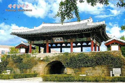
The Kaesong Namdaemun, also known as the South Gate, is one of the historic treasures of Kaesong, an ancient city that was once the capital of the Koryo Dynasty which reigned from the 10th to the 14th century. This gate is part of the old city walls that protected Kaesong and is a fine example of the traditional Korean architecture of the period. Its significance is not only historical but also cultural, as it reflects the sophisticated defensive construction techniques of that era. Throughout the centuries, Kaesong Namdaemun has stood as a silent witness to the turbulent history of the Korean Peninsula, surviving various conflicts and occupations.  - in: https://travelsetu.com

Wednesday, August 21, 2024

TW-3681523 & TW-3706087

 It makes sense to post sunset cards at this time of the day. 

TW-3681523, sent by Ruby.
Sanxiantai is an area containing a beach and several islands located on the coast of Chenggong Township, Taitung County, Taiwan. 
A popular tourist attraction for its rocky coastal views, the area is well known for its long footbridge in the shape of a sea dragon. - in: wikipedia
 In 1987, the government completed the eight cross-sea arch bridge that crosses over to the island. It was designed in the shape of waves, like a prostrate sea dragon and connects Sanxiantai with Taiwan Island. It has become the most famous landmark on the East Coast. - in: https://www.eastcoast-nsa.gov.tw
 
TW-3706087, sent by Esther.
Fangliao Fishing Harbor is one of the nicer fishing harbors around Taiwan. It's easy to reach from the railways station and you can catch nice sunsets there from the bridge over the harbor. 

Sunday, August 11, 2024

Temple of Heaven - China

My 1st Temple of Heaven card was received in 2008. Since then I've received a few more cards from them, all depicting the Hall of Prayer for Good Harvests. The 1st and last cards are officials, the 2nd it was sent by Zhuang and the third was a surprise card sent by Ariana during her holidays in China in 2012.
 
As the largest of Beijing's imperial of religious building complexes, the Temple of Heaven is known for its rigorous symbolic layout, peculiar structure, and magnificent decoration. It is the most representative example of Chinese ritual architecture. Emperors of the Ming and Qing dynasties (from 1420 to 1900) worshiped the god of heaven and prayed for good harvests there. - in: https://www.chinahighlights.com

 
CN-3349388, sent by JinZhu. 
"The Temple of Heaven is a complex of Taoist buildings situated in southeastern urban Beijing, in Xuanwu District. The complex was visited by the Emperors of the Ming and Qing dynasties for annual ceremonies of prayer to Heaven for good harvest. It is regarded as a Taoist temple, although Chinese Heaven worship, especially by the reigning monarch of the day, pre-dates Taoism.

 The temple complex was constructed from 1406 to 1420 during the reign of the Yongle Emperor, who was also responsible for the construction of the Forbidden City in Beijing.

 
The Temple of Heaven was inscribed as a UNESCO World Heritage Site in 1998 and was described as "a masterpiece of architecture and landscape design which simply and graphically illustrates a cosmogony of great importance for the evolution of one of the world’s great civilizations..." as the "symbolic layout and design of the Temple of Heaven had a profound influence on architecture and planning in the Far East over many centuries. 
 
CN-3796327, sent by Jonathan.
"The Hall of Prayer for Good Harvests is a magnificent triple-gabled circular building, 32 metres in diameter and 38 metres tall, built on three levels of marble stone base, where the Emperor prayed for good harvests. The building is completely wooden, with no nails." - in: wikipedia

Saturday, August 10, 2024

UA-1958300

 This official card from Ukraine had already expired when I got it this week. It took it 81 days to get to my mailbox but it finally made it.

There are at least 60 lighthouses in Ukraine. Most of them are located on the coasts of the Black and Azov Seas, but there are exceptions. Which is not the case of this one. Vorontsov lighthouse is located in the Black Sea port of Odesa and guides all ships passing through the harbor. It was the first stationary lighthouse built on a wooden breakwater and installed in 1845.

UA-1958300, sent by Olga.
In 1863, it was converted to cast iron, and in 1867, electric lighting was installed, and it became the world's fourth electric lighthouse.  The Vorontsov Lighthouse is 26 meters high and has 135 steps, its light can be seen at a distance of up to 32 km, and its sound can be heard at a distance of up to 3 km. - in: https://visitukraine.today
The lighthouse is connected with the port's shoreline by a long stone causeway and jetty, which protect the port from the southern high seas.

Kuldiga - Latvia

 I haven't received any cards from Latvia since 2021!! 
A few weeks ago I saw Olga offering cards from Kuldiga and I contacted her. I didn't know much about the town but I knew it was a UNESCO site still missing in my collection. She was at the post office when she read my message and immediately sent the card with a special postmark. 
 
The old town of Kuldiga and the red-brick bridge across the Venta River were included in the UNESCO World Heritage list in September 2023.
Kuldiga is considered one of the most beautiful cities in Latvia. It was founded in 1242 and developed from a small medieval hamlet into an important administrative centre of the Duchy of Courland and Semigallia between the 16th and 18th centuries. The town structure of Kuldīga has largely retained the street layout of that period, and includes traditional log architecture as well as foreign-influenced styles that illustrate the rich exchange between local and travelling craftspeople from around the Baltic Sea. The architectural influences and craftsmanship traditions introduced during the period of the Duchy endured well into the 19th century. - in: https://whc.unesco.org 
The historic buildings of the town and its nature create a unique, harmonious ensemble incomparable to anything found in Latvia or elsewhere in Europe.  

One of the widest brick bridges in Europe has always attracted visitors to Kuldiga. The 164-metre-long bridge was built in 1874 over the Venta River. It is the longest road bridge of this kind in Europe. The bridge, with seven spans of brick arches and boulder abutments, was not only the largest and most ornate on the territory of Latvia but also one of the most modern of its time in the whole of Europe. It was built according to Russian Tsarist road standards: 11 metres wide, allowing two carriages to pass each other on it. The bridge was renovated in 2008. - in: https://thesanetravel.com

FI-4648431

 One day I'll go to Lapland to see the Northern Lights. 
Statistically, the northern lights in Lapland are most likely to be seen from mid-August to mid-April. Every year, the Northern lights are a common sight at Pyhä-Luosto and the past few years have been excellent for observing the northern lights.
 
Kuva/Image: Juha Paso
FI-4648431, sent by Tarja.
To increase the chance of seeing them, there is a  Aurora Alert Realtime system free of charge offered to all visitors in Pyhä and Luosto. Visitors will be able to access it via a mobile data connection or using free Wi-Fi networks offered by local businesses. 
This lean-to-shelter at Isokuru seems a nice place to take a break after a hike and enjoy the lights. 
 

Thursday, August 8, 2024

Still in Jyväskylä

 Different view of the Nero stairs in Jyväskylä. Both to celebrate postcrossing anniversaries and sent by Heidi.
 
The Harju ridge is the best known of Jyväskylä’s observation points and green areas. Ascending its steep slope are the Nero steps, which were named after former city engineer Oskar Nero.
The stone steps are flanked each summer by a fantastic array of flowers.
 

The Nero Stairs that ascend to the top of the ridge are one of Jyväskylä’s more picturesque sights. The robust stairs, whose foot is at the edge of the city centre, were built as an unemployment relief project in 1925.

Jyväskylä - Finland

These cards are both from Jyväskylä. 

Kuva: J. Laine

Jyväskylä is located in the western part of the Finnish Lakeland. With a population of 135,591, is the largest city in the region of Central Finland. 
 
 
Photo: Markku Könkköla


 FI-1816873, sent by Eira. 
 Jyväskylä City Church is located in the heart of city. The church building was completed in 1880, five years after the establishment of the city parish. The church was designed by architect L. I. Lindqvist and construction led by the Swedish-born architect, Anders Johan Janzon. The red-brick church replaced the earlier wooden church built in 1775.  The new church was needed since the early 1850s due the poor condition and location of old church. When the new church was completed, it was the first stone church in Central Finland. Architecture includes both neo-Roman and neo-Gothic features. - in: http://www.spottinghistory.com

Tuesday, August 6, 2024

Hämeenlinna - Finland

Officials from Hämeenlinna, a city in the south of Finland.

FI-1404345, sent by Kari.
Hämeenlinna is a city and municipality of about 67,000 inhabitants in the heart of the historical province of Häme in the south of Finland and is the birthplace of composer Jean Sibelius.
Nearby cities include the capital Helsinki (98 km/61 mi), Tampere (73 km/45 mi) and Lahti (72 km/45 mi).


FI-1850033, sent by Anna.
The medieval Häme Castle (Hämeen linna) is located in the city. - in: wikipedia
The City of Hämeenlinna was founded in 1639. Hämeenlinna presents the ideal combination of nature and culture. Already 372 years old, the city is full of historical sights and surrounded by beautiful nature reserves. - in: http://www.hameenlinna.fi/english/