Thursday, May 26, 2022

PT-741492

For those who like outdoor activities, especially hiking, the Pap of Glencoe walk is a popular hike in the Scottish Highlands.

 
Photo: Jess Connolly
PT-741492, sent by Madalena.
The Pap of Glencoe or  Sgurr na Cìche translates as “Peak of the Breast” situated on the northern side of Glencoe, in the Highlands of Scotland. It lies at the western end of the Aonach Eagach ridge, directly above the point where the River Coe enters Loch Leven. - in: https://www.outdoorcapital.co.uk

Jodrell Bank Observatory - UK

No, this is not a stage of a summer music festival, is not a space ship and is not an attraction in an amusement park. This structure is the Lovell Telescope at Jodrell Bank Observatory in Cheshire, in the north-west of England. The observatory is a UNESCO WHS since 2019. 
The card was sent by Stella.

Located in a rural area of northwest England, free from radio interference, Jodrell Bank is one of the world's leading radio astronomy observatories. At the beginning of its use, in 1945, the property housed research on cosmic rays detected by radar echoes. This observatory, which is still in operation, includes several radio telescopes and working buildings, including engineering sheds and the Control Building. Jodrell Bank has had substantial scientific impact in fields such as the study of meteors and the moon, the discovery of quasars, quantum optics, and the tracking of spacecraft. This exceptional technological ensemble illustrates the transition from traditional optical astronomy to radio astronomy (1940s to 1960s), which led to radical changes in the understanding of the universe. - in: https://whc.unesco.org

 
The Lovell telescope, with its 76 metre diameter reflecting surface, has stood over the Cheshire plain since construction was completed in 1957. 
Since then, the telescope has been upgraded several times and it remains one of the biggest and most powerful radio telescopes in the world, spending most of its time investigating cosmic phenomena which were undreamed of when it was conceived. 
It was given a Heritage Grade I listing in 1988. - in: https://www.jodrellbank.net

Baden bei Wien - Austria

In this last month I've tagged and swapped more than usual in order to received UNESCO cards from sites I was still missing. It has been awhile since I received so many new sites in such a short period of time. It almost feels like in the old days. 
This card, with a matching cancellation postmark, was sent by Anita.

Baden bei Wien in Austria, is one of the 11 spa towns from 7 european countries, which were added to the World Heritage List last year. 
The Romans valued the warm healing springs of Baden so much that they even named the location after these springs: ‘Aquae’, or ‘Bäder’ in German. The spring tapped into by the Romans continues to bubble away today and is also open to visitors. This is also the case for the 13 other sulphur thermal springs in the city area; these carry warm ‘yellow gold’ to the surface from a depth of around 1000 meters, which reaches up to 36°C. However, Baden gained its reputation as a health resort around 1,700 years after the Romans discovered the spring. Empress Maria Theresa frequently visited Baden. The Theresiengarten (now the spa park) and the Theresienbad (now the site of the casino) were also named after her at the time. From 1796 to 1835, when Emperor Franz I and his court spent every summer in the spa town, Baden was even labelled as the secret capital of the Austro-Hungarian Monarchy for a few months each year. Everyone who was anyone in Vienna, only 26 km away, followed the emperor and travelled to noble Baden for the spa treatment, including the nobility, the rich bourgeoisie and, of course, numerous artists. - in: https://www.lower-austria.info

 
Foto: Bwag
The Kurhaus was built in 1885-86 on the site of the old Theresien and Ursprungs baths as well as the old pump rooms. In terms of function, it replaced the Redoutensaal (ballroom), which was demolished in 1908 to make room for the new Stadttheater. Nowadays, the Kurhaus serves as the Congress Casino, which was built in 1934 - as the first year-round casino - and moved to the present Kurhaus location in 1968; renovated in 2007, it is currently the second largest casino in Europe. The ballroom, which was altered in 1934, was returned to its original appearance in 1999. - in: https://www.tourismus.baden.at

Monday, May 23, 2022

Piazza Maggiore, Bologna - Italy

When it comes to UNESCO places and cards, Bologna was one of my frustrations. I've been to the city, I've seen and walked under the porticoes but couldn't find any cards of them. Don't you hate when this happens? Almost 4 years after my visit to the city and 1 year after it's inscription on the World Heritage Site list, I finally have a card of the Porticoes of Bologna. Grazie Alessandro.

The porticoes of Bologna are a heritage of the city and one of its symbols.
The serial property comprises twelve component parts consisting of ensembles of porticoes and their surrounding built areas, located within the Municipality of Bologna from the 12th century to the present. These portico ensembles are considered to be the most representative among city’s porticoes, which cover a total stretch of 62 km. Some of the porticoes are built of wood, others of stone or brick, as well as reinforced concrete, covering roads, squares, paths and walkways, either on one or both sides of a street. - in: https://whc.unesco.org
For over ten centuries now, the porticos have been appreciated as sheltered walkways, as a meeting point, a place for aggregation and socialising for both locals and visitors, and it is precisely this social aspect that distinguishes these covered spaces, which were and still are privately owned for public use while being considered the most identifying feature of the city.

 
Pavaglione, Banchi and Piazza Maggiore are one of the 12 components of this site. 
The Pavaglione (from 'Papilio', the name of the silkworm sold right under the portico in Piazza Maggiore) is undoubtedly Bologna's most iconic portico. Located in the eastern part of the square under the Palazzo dei Banchi, it was built in the 15th century with the dual function of dividing the elegant Renaissance square from the intricate, chaotic and odorous maze of streets of the "Quadrilatero" (the ancient medieval market) and  providing a suitable place for the city's bankers to conduct their business and set up money-changing desks in a city that had by then reached a decidedly cosmopolitan dimension, thanks to the presence of countless students from different European and international countries. - in: https://www.bolognawelcome.com

Sunday, May 22, 2022

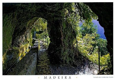
Levada do Caldeirão Verde

This pandemic has deprived me of one of the things I like the most, to travel by plane but last month, after two and a half years, I finally flew again. Every time I thought about where I would go when I got back on a plane, Madeira island was always one of the first options that came to my mind. 
On my 2nd visit to the island, 3 years ago, I became a fan of the levadas and on this visit I wanted to hike another one, the Levada do Caldeirão Verde. It is a very beautiful hiking trail, with fantastic landscapes and views, worthing every km and sore muscles. 

The Levada do Caldeirão Verde hiking trail begins at Queimadas Park, near Santana. It has a length of 6.5 km to which you can add 2.2 km if you decide to go the rest of the way to Caldeirão do Inferno. In total there will then be 6.5 km + 6.5 km (13 km, round trip) or 8.7 km + 8.7 km (17.4 km, round trip). It has a medium difficulty level.

 
Objecto Anónimo, Lda
The levada of Caldeirão Verde is an impressive work of art built in the 18th century that begins in the main stream bed of the Caldeirão Verde brook. Passing through steep cliffs and mountains, it carries the water that runs off the highest mountains of Madeira, to be used to irrigate the farm lands of the parish of Faial.
This levada is used for agricultural purposes, but it is also an important means of reaching the interior of the deep valley of the São Jorge brook on foot, offering the traveler a spectacular view of the mountainous terrain of the interior of the island and the opportunity to walk through tunnels carved by hand out of the rock.
 
 Objecto Anónimo, Lda
After you pass through the 4 tunnels on the route, Caldeirão Verde appears on the left of the levada.
The Caldeirão Verde lake is formed by water that falls from the bed of the Caldeirão Verde stream bed from a height of approximately 100m.
Indulge yourself and revel in the surrounding scenery and catch your breath for the return trip. - in:
https://www.visitmadeira.com

PT RR - Surprise Group * May '22

 Tiago is noo the new host of this RR of the Portuguese speaking community and the surprise groups are back. 
These cards are all very different from each other but they have one thing in common, they are all the north of Portugal.

fotografia: Oswaldo Santos

 
I've been to Braga several times, I've visited this sanctuary, I bought several postcards of it but this is the first time I receive a postcard from there and post it here. Nídia sent it because she saw that I like churches. Let's find outa little more about the Bom Jesus Sanctuary, classified as a World Heritage Site since 2019.
Located on the slopes of Mount Espinho, overlooking the city of Braga in the north of Portugal, this cultural landscape evokes Christian Jerusalem, recreating a sacred mount crowned with a church. The sanctuary was developed over a period of more than 600 years, primarily in a Baroque style, and illustrates a European tradition of creating Sacri Monti (sacred mountains), promoted by the Catholic Church at the Council of Trent in the 16th century, in reaction to the Protestant Reformation. The Bom Jesus ensemble is centred on a Via Crucis that leads up the western slope of the mount. It includes a series of chapels that house sculptures evoking the Passion of Christ, as well as fountains, allegorical sculptures and formal gardens. The Via Crucis culminates at the church, which was built between 1784 and 1811. The granite buildings have whitewashed plaster façades, framed by exposed stonework. The celebrated Stairway of the Five Senses, with its walls, steps, fountains, statues and other ornamental elements, is the most emblematic Baroque work within the property. They are framed by lush woodland and embraced by a picturesque park that, masterfully set on the rugged hill, highly contributes to the landscape value of the ensemble. - in: https://whc.unesco.org 

This is a beautiful postcard from Gerês, but the first thing I thought when I received it was that all these photos would made beautiful postcards. In April Tiago was on vacation and toured Gerês from one end to the other.
The Peneda-Gerês National Park, also known simply as Gerês, is a national park located in northern Portugal. Created on 8 May 1971, it is the oldest protected area and the only national park in Portugal. It covers an area of 695.93 km2 (268.70 sq mi), occupying the Districts of Viana do Castelo, Braga, and Vila Real and bordering the Spanish Baixa Limia – Serra do Xurés natural park to the north, with which forms the UNESCO biosphere reserve of Gerês-Xurés. - in: wikipédia
This is a mountainous region, composed mainly of granite, with points of high altitude where the effects of the latest glaciation can be seen. Deep and embedded valleys support a dense hydrographic network.
Peneda-Gerês National Park, is also rich historical and cultural heritage (megalithic necropolis, traces of romanization, castles, traditional granaries with corncobs, ovens, mills, dams, terraces, etc.) and visitors can learn more about it exploring the mountain villages and seeing the presence of well-preserved traditional architecture sets. - in:
https://natural.pt

fotografia: Oswaldo Santos

Very famous since the beginning of the 20th century, Moledo Beach is frequented by families of politicians, public figures and also Eric, a well-known postcrosser! 
In an area of great natural beauty, surrounded by the Camarido protected area, this Beach is somewhat windy with strong waves reaching shore here creating good year round surfing conditions and windsurfing during the summer.
In front of Moledo Beach is a small rocky island that can be visited by boat. On the island is the Ínsua Fortress, built in the 15th century as a convent before, in the 17th and 18th centuries undergoing conversion work that transformed it into a coastal defence post. - in: https://www.visitportugal.com

Thursday, May 19, 2022

Monthly Fav. Surprise RR * March 22

I usually join this RR with 4 cards, which means I'll send and receive 4 cards. However in March, the host gave me 5 addresses and that wasn't an issue at all. I've got these great cards from Taiwan, Belgium, Germany, Finland and Japan.

www.papersisters.de

 
Bubble tea, blue and white slippers, Dajia Mazu pilgrimage, night markets, Taipei 101, Yehliu geopark, are all famous things and places in Taiwan. By the way, did you know that bubble tea was invented in Taiwan? 
New card in the HP from collection. Thank you Angel.

 
www.papersisters.de
 
I was already happy with the new HP from Taiwan card but Lara made be happier with this Belgium card. 
Small but a very interresting country. My trip to Belgium in 2011 was one of my best trips ever. 

© Schöning Verlag
Sabine sent me this beautiful lighthouse card, from my favs, and used a matching stamp.
Schleimünde Lighthouse, in state of Schleswig-Holstein, at Western coast of the Baltic Sea, was built in 1871. 

 Photo: Taneli Eskola 2019
 
In Liesjärvi National Park you've a chance to try your hand at traditional farm work at the Korteniemi Heritage Farm. You can also meet livestock and experience how people lived 100 years ago. The farm is a real park ranger’s estate from the 1910s, and several indigenous species of livestock, including cows, sheep, chickens and a rooster, are still kept there in the summer. Old Finnish crops are grown in the fields and vegetable gardens using traditional methods. Rye is still cut with scythes, dried in stooks and threshed with flails. - in: https://www.discoveringfinland.com 
Card sent by Flora and also signed by 5 other postcrossers who attended a meeting in Mikkeli. 

 
Sakurajima (桜島) is one of Japan's most active volcanoes and the symbol of Kagoshima. The volcano smokes constantly, and minor eruptions often take place multiple times per day. Located in the middle of Kagoshima Bay, Sakurajima is the area's most prominent geographic feature, having an elevation of 1117 meters and a circumference of about 50 kilometers. 
Before a powerful eruption in 1914, Sakurajima used to be an island in the bay, but the massive lava flow from that eruption created the volcano's current land connection to the Osumi Peninsula in the east. - in: https://www.japan-guide.com
Card sent by Tomoko.

Wednesday, May 18, 2022

Cuyahoga Valley National Park - USA

When it comes to American national parks, we mostly hear about Yellowstone, Yosemite, Grand Canyon but there much more to learn about and explore. 
These cards were sent by Carol and Vinny.

Cuyahoga Valley is the only national park in the state of Ohio and one of three in the Great Lakes Basin. It  that preserves and reclaims the rural landscape along the Cuyahoga River between Akron and Cleveland in Northeast Ohio.
The park was originally designated as a National Recreation Area in 1974, then redesignated as a national park 26 years later in 2000.

The Cuyahoga Valley National Park is home to some of the most picturesque waterfalls in the country. In fact, the park was among 10 cited recently for their exceptional falls in Park Advocate, the National Parks Conservation Association’s blog.There are about 100 waterfalls in the Cuyahoga Valley with most in the northern part of the park.

By Kim Smith
Brandywine Falls in Sagamore Hills Township is the tallest waterfall in the park and the tallest in Northeast Ohio: 65 feet. It is flanked by wooden observation decks accessible off Brandywine Road. You can hike in the Brandywine Creek gorge below the falls. - in: https://eu.beaconjournal.com

US-8343785

A lighthouse in Wisconsin.

 
US-8343785, sent by Donna.
A major feature of Point Beach is Rawley Point and the lighthouse operated by the U.S. Coast Guard. The Coast Guard has operated a lighthouse here since 1853.
The first lighthouse was a brick tower and home that served mariners until 1894, when a new steel tower was installed.
The light is atop this steel tower that rises 113 feet above the lake surface and is one of the largest and brightest on the Great Lakes. It is visible up to 19 miles away and operates from a half hour before sunset until a half hour after sunrise.
The old brick light tower was cut down, roofed and became a part of the keeper's house. These structures, framed by evergreens and a blue sky, have become a scenic attraction in Wisconsin.
Before the new lighthouse was built, 26 ships foundered or stranded on the point. They included 20 schooners, a barge, two steamers and three brigs. The most tragic sinking in the point's unpleasant history occurred in 1887, when the steamship Vernon went down in heavy seas. One of the largest steamers on the lakes at the time, the Vernon took 36 crew members and passengers to their deaths. The cause of the sinking remains a mystery.
Since the lighthouse went into operation, however, the tragedies have come to an end. - in: https://dnr.wisconsin.gov

Thursday, May 5, 2022

Bamileke people - Cameroon

Today there was a great surprise for me in my mailbox. My first, and real, written and stamped card from Cameroon. How cool and unique is this?? I don't often get African cards, much less, written and stamped from there. Thank you very much Eric. 

On the card there's a Bamileke dancer performing a funeral dance with  an elephant mask. 
The Bamileke are a Grassfields ethnic group. They make up one of the largest ethnic groups in Cameroon and are natives of the country's West. The Bamileke are subdivided into 106 groupings in the West region led by a King or fon.


Masquerades are an integral part of Bamileke culture and expression. Colorful, beaded masks are donned at special events such as funerals, important palace festivals and other royal ceremonies.
The power of a Bamileke king, called a Fon, is often represented by the elephant, buffalo and leopard. Oral traditions proclaim that the Fon may transform into either an elephant or leopard whenever he chooses. An elephant mask, called a mbap mteng has protruding circular ears, a human like face, and decorative panels on the front and back that hang down to the knees and are covered overall in beautiful geometric beadwork, including much triangular imagery.
Beadwork, shells, bronze and other precious embellishments on masks elevate the mask's status. . in:
wikipedia
 

Monday, May 2, 2022

EE-291443

These last weeks I've been receiving official cards from countries I usually don't receive cards from. New Zealand, Norway, Luxembourg and also Estonia. It's nice to get such a variety of ID's.

EE-291443, sent by Katrin.
Kambja Church of the Estonian Evangelical Lutheran Church is the biggest country church in Southern Estonia.
The first wooden church of Kambja was built probably in the beginning of the 14th century. Churches were destroyed and rebuilt several times during centuries. The present Lutheran St. Martin’s Church was originally rebuilt in 1720, this time of stone and a transept was added to the old part in 1874. After World War II, the church, which is one of the biggest in Southern Estonia, was in ruins for many years until restoration began in 1989. - in:
https://www.spottinghistory.com
Today, its good acoustics and almost 600 seats make it a great venue for concerts or wedding ceremonies. 

Porvoo - Finland

I've planned trips to Finland a few times and I've always included Porvoo in my itinenary. However, when I finally made it to Finland, I didn't get to visit the city!!

© Maria W Boström 2010
FI-2993413, sent by Isabel
Founded nearly 800 years ago, Porvoo is the second oldest city in Finland and evidence of its long history can still be seen and felt as you walk its charming streets. For centuries, the city has served as both a home and a source of inspiration for many Finnish artists.
Located about 50 kilometres east from Helsinki, it is possible to travel from the capital to Porvoo by steamboat in the summer. Even though Porvoo is not exactly a coastal town, it is connected to the Gulf of Finland via the Porvoo River. The river flows through the city, passing Porvoo’s most well-known landmarks: its red shore houses. Originally, the shore houses were painted red in honour of the arrival of Gustav III, the king of Sweden.
Historically, Porvoo has been an important centre of trade and the shore houses were once used to store goods and produce, such as exotic delicacies from distant lands. - in: http://www.visitfinland.com/article/summertown-porvoo/
 
Photography: Niko Laurila
FI-4159433, sent by Nina.
Porvoo Cathedral is a gothic cathedral of the Evangelical Lutheran Church of Finland, built in the 15th century, although the oldest parts date from the 13th century.
Porvoo Cathedral was burnt down several times in the 16th century: In 1508 the church was destroyed by the Danes, in 1571 and 1590 it was burnt down by the Russians. In the 17th century, the church was restored, but in 1708, during the Great Northern War (1700-1721), it was burnt down again. At that time, the building was completely destroyed, except for the soot-covered walls, the shell vault and the vault of the northern ship. During the Continuation War in 1941, the church was hit by a bomb which fell through the roof and vaults without exploding. Finally, on May 29th 2006, the roof of the church burned completely due to arson. 
The Cathedral is known to have temporarily become the "Parliament of Porvoo", opened in the Cathedral in 1809. It was in this setting that the declaration of the sovereign Alexander I (1801-1825) took place, transferring the eight former provinces of Sweden that constitute Finland to the power of the Russian emperor. - in: https://religiana.com