Saturday, April 13, 2013

Kazimierz Dolny & Sandomierz

Polish cards from Kazimierz Dolny and Sandomierz, both sent by Emerich.
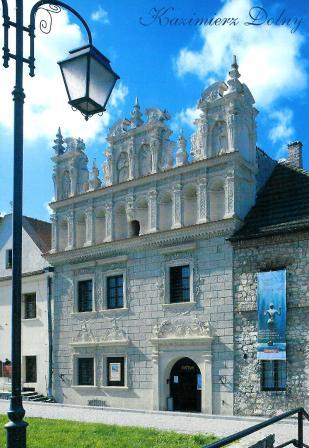
 Photo by Dariusz Krakowiak
Kazimierz Dolny is a small town in Central Poland.
This is the Celej House also know as St. Bartholomew house due to the figure of the saint on the right-facing façade.
It was probably buil in the 16th century and its owner was a rich merchant and town concillor Bartlomiej Celej.
The richly decorated façade has all the caractheristic forms used by the sculptors and builders of the time. There are animals, plants and querubs. On this particular façade there is Jesus Christ as the Savior of the world, and St. Mary as Queen of Heaven. On the left there's St. John the Baptist with a Cross and St, Bartholomew with a knife.
After World War II, Karol Sicinski had his architectural studio here. It was there where the reconstruction of Kazimierz Dolny was planned and prepared.
In 1964 the house became the seat of Regional Museum, which in 1972 became Kazimierz Dolny Museum and in 1987 was given the name of Nadwislanskie Museum. Nowadays, the exhibits works of artists who were inspired by Kazimierz Dolny. - in: http://www.kazimierzdolny.eu/monuments/108/

Photo by Dariuz Krakowiak
Sandomierz is a town in south-eastern Poland, known for its Old Town, a major tourist attraction. This beautiful building is the town hall, built in the 14th century. It initially had a form of tower. Due to a rebuilding in the 15th C., the structure got the shape of a lengthened rectangle. A century later, it got a high attic, decking the whole roof, and in the beginning of the 17th C. a tower was added on the western side.
The building went through several fires, mainly in 1623 and 1757, yet luckily it is made of brick, so the construction has not been completely damaged.
Moreover, a spacious cellar has been lately discovered under the building. The room could have been used as prison where the accused were tortured, as there are hooks and rings attached to the walls. Yet, these are not only remarkable elements of this object. In another part of the building, there is a residence of the Regional Museum with historic and artistic exhibitions.
The Town Hall’s interiors are also noteworthy because of the late-Renaissance, neo-Renaissance and neo-Baroque furniture. The historic department of the museum covers the ground floor of the building, while on the first floor there is a wedding hall and the rooms of the City Council. In the basement one can find “Lapidarium” (“The Lapidary”), a club of the Sandomierz Cultural Society. - in: http://www.wrota-swietokrzyskie.pl/608

Romanian Unesco WHS

The last time i've got a romanian card was more than a year ago... but after a year without any card from there, i've got these from the last 2 Unesco Whs i was missing from Romania, the Dacian Fortresses of the Orastie Mountains and Horezu Monastery. The 1st card was sent by Fabienne and the 2nd by Manu.

 Built in the 1st centuries B.C. and A.D. under Dacian rule, these fortresses show an unusual fusion of military and religious architectural techniques and concepts from the classical world and the late European Iron Age. The six defensive works, the nucleus of the Dacian Kingdom, were conquered by the Romans at the beginning of the 2nd century A.D.; their extensive and well-preserved remains stand in spectacular natural surroundings and give a dramatic picture of a vigorous and innovative civilization. - in: http://whc.unesco.org/en/list/906

Photo by C. P. C. S.
Founded in 1690 by Prince Constantine Brancovan, the monastery of Horezu, in Walachia, is a masterpiece of the 'Brancovan' style. It is known for its architectural purity and balance, the richness of its sculptural detail, the treatment of its religious compositions, its votive portraits and its painted decorative works. The school of mural and icon painting established at the monastery in the 18th century was famous throughout the Balkan region. - in: http://whc.unesco.org/en/list/597

Thursday, April 11, 2013

Ukrainian Carpathians

This card, sent by Marina is so, so beautiful. I'd love to be there. Yes, I'm crazy about snow, it should snow like this here. Well, last winter was kinda good, it snowed a couple of times but after 2 days the snow was all gone. I miss the snow storms from the past.

The card shows a traditional wooden hut on Khormiakiv shieling, mountain range Gorgany, in Western Ukraine in Outer Eastern Carpathians.

Lufa Photos
The Carpathian Mountains or Carpathians are a range of mountains forming an arc roughly 1,500 km (932 mi) long across Central and Eastern Europe, making them the second-longest mountain range in Europe.
The Carpathians consist of a chain of mountain ranges that stretch in an arc from the Czech Republic (3%) in the northwest through Slovakia (17%), Poland (10%), Hungary (4%) and Ukraine (11%) to Romania (53%) in the east and on to the Iron Gates on the River Danube between Romania and Serbia (2%) in the south.
The Carpathians are usually divided into three major parts: the Western Carpathians (Czech Republic, Poland, Slovakia), the Central Carpathians (southeastern Poland, eastern Slovakia, Ukraine, Romania), and the Eastern Carpathians (Romania, Serbia). - in: wikipedia

UA-450939, UA-484165 & UA-465690

Officials from Ukraine.

 UA-450939, sent by Elia.
This beautiful cathedral is located in Lugansk, a city in southeastern Ukraine
St. Vladimir's Cathedral is a unique structure. Its construction began in 1993 and it was consacrated in 2006.
The cathedral is one of the biggest religious building in southeast Ukraine.

UA-484165, sent by Liv.
These are a few ukrainian temples in different cities.
Clockwise direction: Eletsky monastery cathedral in Chernihiv; St. Michael's Golden-Domed Monastery in Kiev;  Feodosiya's fortress and church; Mhar Monastery; wooden orthodox church of the Holy Spirit in Potelich; the Holy Trinity Church within the fortified monastery in Mezhyrich; Church of St John the Baptist in Kerch; Carmelite convent in Berdychiv; Korec's monastery; Bakhchisaray Cave Monastery; Molchansky Monastery in Putyvl; St. George's Cathedral in Lviv and in the middle Holy Dormition Pochaiv Monastery.

UA-465690, sent by Anastasia.
Finally, my 2nd card from Sevastopol, showing some of the city's monuments, such as the Monument to Sunken Ships. The installation of the monument was timed to match the 50th anniversary of the first defense of Sevastopol, when Russian sailing ships were sunk for the sake of saving Sevastopol.

RU-1467882

Another Belarus card but sent as an official from Russia. The card depicts three churches in Brest.

RU-1467882, sent by Vika.
These are the St. Nicholas Community Church; St. Simon Orthodox Cathedral and St. Nicholas Garrison Cathedral.

Wednesday, April 10, 2013

Cathedral of Saint Virgin Mary - Belarus

This card was sent by Kasia, who contacted me via the official postcrossing site.

This is a Roman Catholic baroque cathedral in Minsk.
The cathedral was built in 1710 as a church of the Jesuit monastery. In 1793, after Russia's taking over Belarus, the Jesuit order was banned and the church got a local status. Soon, after creation of the Minsk diocese, the church became the local cathedral.
The Cathedral was heavily damaged in a fire in 1797, but was later fully renewed. 
In 1920, Bishop Lazinski was arrested by Soviet authorities, the cathedral was closed down in 1934.
During the Second World War, the Germans allowed the cathedral to function again, but after the war it was again closed down by the Soviets. In 1951, the cathedral's bell towers were intentionally destroyed by Soviet artillery and the building itself was given to the Spartak sports society.
In the beginning of the 1990s, religious services started again. In 1993, the building was given back to the Roman Catholics; by 1997 it was renewed. - in: wikipedia

Tuesday, April 9, 2013

Struve Geodetic Arc - Russia

To have all the russian Unesco sites i only needed a card of one of the two russian Struve Geodetic Arc points and i got it thanks to Galina. One more completed country.
This is a card of the Gogland or Hogland island, in the Gulf of Finland in the eastern Baltic Sea, about 180 km west of Saint Petersburg and 35 km from the coast of Finland.

Since 1826, the hill Mäkiinpäällys has two of the points in the Struve Geodetic Arc.
The gentleman on the card is Friedrich Georg Wilhelm von Struve, the german astronomer who initiated the Struve Geodetic Arc.