Sunday, July 23, 2017

DE-6369546

The ID of this card is german but the card is from USA. Unalaska is the largest city of the Aleutian Islands, a chain of 14 large volcanic islands and 55 smaller ones belonging to both the United States and Russia. The city of Unalaska, covers part of the Unalaska island, in the US state of Alaska.
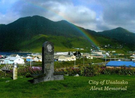
DE-6369546, sent by Rüdiger.
During World War II the remote Aleutian Islands, home to the Unangax̂ (Aleut) people for over 8,000 years, became a fiercely contested battleground in the Pacific. This thousand-mile-long archipelago saw invasion by Japanese forces, the occupation of two islands; a mass relocation of Unangax̂ civilians; a 15-month air war; and one of the deadliest battles in the Pacific Theater. - in: https://www.nps.gov/aleu/index.htm
A memorial overlooking downtown Unalaska is dedicated to the Unangax who were forcibly evacuated during WWII and the Aleutian villages that were never resettled. - in: http://www.alaskapublic.org/2017/06/02/75th-anniversary-of-aleut-evacuation/

Wednesday, July 19, 2017

US-4680108

The Cloud Gate Sculpture, also known as the "bean," is one of the highlights of Millennium Park in Chicago. 

Photo: Jeff Lewis
US-4680108, sent by Donna.
Designed by the artist Anish Kapoor, the Chicago the Bean sculpture is made of 168 highly polished stainless steel plates - giving the appearance of liquid mercury. Up close, the highly reflective nature of the sculpture captures the beautiful skyline of Chicago. The Cloud Gate Sculpture has thus become a tourist hot spot and is the perfect place to take your vacation snapshots. - in: http://www.chicagotraveler.com/cloud-gate-chicago

Sunday, July 9, 2017

US-4230848

An official from USA with the famous Liberty Bell. 

Photo: David Traub
US-4230848, sent by Sarah.
In 1751, the Pennsylvania Provincial Assembly—part of the state’s colonial government—paid around 100 pounds for a large bell to hang in its new State House (later known as Independence Hall). Cast at London’s Whitechapel Bell Foundry, the bell arrived in Philadelphia in August 1752.
On July 8, 1776, the bell was rung to celebrate the first public reading of the Declaration of Independence. After the British invasion of Philadelphia, the bell was hidden in a church until it could be safely returned to the State House. A popular icon of the new nation and its independence, it wasn’t called the “Liberty Bell” until the 1830s, when an abolitionist group adopted it as a symbol of their own cause.
After being moved to a pavilion near Independence Hall in 1976 (the bicentennial of the Declaration of Independence), in 2003 the Liberty Bell was relocated to Liberty Bell Center in Independence National Historic Park, where millions of visitors view its famous crack each year. - in: http://www.history.com/news/ask-history/why-is-the-liberty-bell-cracked

Mauna Kea - Hawaii

I always wanted to have a postcard with a snowy view of any of the Hawaii's vulcanoes and I finally got one, thanks to Trisha. 

Photo: Peter French
Mauna Kea is a dormant volcano on the island of Hawaii. Standing 4,207 m (13,802 ft) above sea level, its peak is the highest point in the state of Hawaii. Much of the mountain is under water; when measured from its oceanic base, Mauna Kea is over 10,000 m (33,000 ft) tall. Mauna Kea is about a million years old, and has thus passed the most active shield stage of life hundreds of thousands of years ago.
With its high elevation, dry environment, and stable airflow, Mauna Kea's summit is one of the best sites in the world for astronomical observation. Since the creation of an access road in 1964, thirteen telescopes funded by eleven countries have been constructed at the summit. The Mauna Kea Observatories are used for scientific research across the electromagnetic spectrum from visible light to radio, and comprise the largest such facility in the world. - in: wikipedia

Friday, July 7, 2017

São Nicolau waterfall - São Tomé

This is not my 1st card from São Tomé but is my 1st written and stamped from there. It was sent by Vitória who went on holidays to this small country em April/May.

São Nicolau is not the biggest waterfall but is the best known and very accessible from the city.

Monday, July 3, 2017

Vanuatu's Underwater Post Office

This card is rather unique and sent from an unique post office. Off Hideaway Island in Vanuatu is possible to sent a waterproof card from an underwater post office. That's exactly what Tracey did. How cool is this?? 

Vanuatu Post has created an official Post Office with a difference. It is the world’s only Underwater Post Office..   
Situated within the Hideaway Island marine sanctuary, the Post Office sits in around three metres of water and both divers and snorkellers are able to post special “waterproof postcards”. If snorkellers cannot duck-dive down that far, Hideaway Island staff will be on the spot to help out.

Photo: Andy Belcher
During opening hours the cards will be cancelled/embossed by the postal staff in the Underwater Post Office. Instead of being stamped with ink to show that the card has been sent, the Post office has developed a new embossed cancellation device. 
Placed on site by Vanuatu Post, this official and currently unique postal location was approved by local Ni Vanuatu and opened for business in May 2003.
Opening hours are posted on the beach at Hideaway Island, and a special flag is raised on a float above the site when there are postal workers in the water. 
Out of hours the post cards can be posted in the underwater post box attached to the post office or taken to the main post office in town. All are guaranteed to receive the special cancellation from this unique underwater paradise before being delivered both locally and internationally. - in: http://www.vanuatupost.vu/index.php/en/underwater-post

Tam Coc - Vietnam

Yesterday the 41st session of the UNESCO Committee started it's meeting in Krakow. This means that in the next few days new sites will be added to the WHS list. I'm not too excited about this because this year most of the candidates seem a bit hard to get, I think I only have a card from a german candidate and I hope this one will be classified. 

Three years ago Vietnam had Trang An Landscape Complex classified as UNESCO site. Tam Coc is a popular tourist destination in north Vietnam and part of this site.
This card was sent by Vuong Phan. 

Tam Coc is located about 90 kilometers south of Hanoi in Ninh Binh province and 7 kilometres to the West of the city of Ninh Binh.
Tam Coc which means 3 caves, is a zone of Vietnam that elapses between rice paddies, bathed by the Ngo Dong River punctuated by karstic rock formations and limestone caves.
The rock formations, caves, water and landscape have made Tam Coc to know popularly as Halong Bay on land or between rice paddies Halong Bay. More accessible than her older sister, Halong Bay, Tam Coc which squanders spectacular landscapes and exoticism.
The natural landscape of Tam Coc runs in a small rowing boat plying the River Ngo Dong, where in addition to the impressive landscape we can also contemplate the rice fields. 
Undoubtedly the most impressive of Tam Coc are rice fields when at its best, with a bright green with yellow, ending in the beginning of the cliffs of the rock formations.
The Vietnamese call the paddy fields of Tam Coc as the Green Sea. - in: http://en.vietnamitasenmadrid.com/2012/03/tam-coc.html