Monday, March 14, 2022

US-8167838

The Santuario de Nuestra Señora de Guadalupe is a historic Catholic shrine in Santa Fe, New Mexico. Established in the 1770’s, is the oldest standing shrine in the United States.

 
Photo: Richard Cummins
US-8167838, sent by Rebecca.
It was built in honor of our Lady of Guadalupe and is an enduring landmark, commemorating the apparitions of Mary in 1531 to the Aztec peasant Juan Diego of Tepeyac, Mexico. 
The Santuario de Guadalupe is an adobe structure that sits off the banks of the Santa Fe River near the end of the Camino Real. The original church was constructed on a Latin cross floor plan, with thick 3 foot adobe walls, a flat roof supported by pine vigas, a dirt floor and a 3 tiered bell tower. The parish flourished until 1922 when a fire razed the church's roof, collapsed the spire and damaged the painted frescoes. The walls and altar survived. Restoration this time was made in the style of a California Mission with a new pitched roof, a bell tower and a wooden floor.
The newest addition to the Santuario de Guadalupe is a 12 foot statue that stands in front. - in:
https://www.santafe.org/blog/post/guadalupe/

Mexican UNESCO Sites

I usually get super excited when I receive cards from UNESCO sites but these from Mexico didn't impress me much. The quality of the pictures, the paper, even the cut, isn't that good, it really seems an homemade kind of thing. Homemade or not, there are four sites that I'm not missing anymore. 
The three cards with Mexican stamps were sent by Gabino and the other one was sent by Óscar.


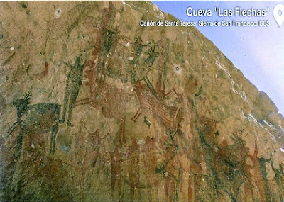
Cueva "Las Flechas" is part of the group of cave paintings in the canyon of Santa Teresa in the San Francisco mountain range. The canvas on the rock wall describes some human figures, apparently a female and a male representation. These paintings are among the most visually attractive in the region.
From c. 100 B.C. to A.D. 1300, the Sierra de San Francisco (in the El Vizcaino reserve, in Baja California) was home to a people who have now disappeared but who left one of the most outstanding collections of rock paintings in the world. They are remarkably well-preserved because of the dry climate and the inaccessibility of the site. Showing human figures and many animal species and illustrating the relationship between humans and their environment, the paintings reveal a highly sophisticated culture. Their composition and size, as well as the precision of the outlines and the variety of colours, but especially the number of sites, make this an impressive testimony to a unique artistic tradition. - in: https://whc.unesco.org

 
El Pinacate and Gran Desierto de Altar Biosphere Reserve (EPGDABR) is located in the Sonoran Desert.
EPGDABR has a surface of 714,566 hectares with 354,871 hectares of buffer zone. It is a large and relatively undisturbed protected area which comprises two very distinct broad landscape types. To the East, there is a dormant volcanic area of around 200,000 ha, comprised of the Pinacate Shield with extensive black and red lava flows and desert pavement. The volcanic shield boasts a wide array of volcanic phenomena and geological formations, including a small shield-type volcano. The most visually striking feature is the concentration of a total of 10 enormous, deep and almost perfectly circular Maar (steam blast) craters.
In the West towards the Colorado River Delta and South towards the Gulf of California, is the Gran Altar Desert, North America's largest field of active sand dunes and only active Erg dunes. - in: https://whc.unesco.org

The Prehistoric Caves of Yagul and Mitla in the central valley of Oaxaca is an extensive cultural landscape that includes caves and shelters, one of which, the Guilá Naquitz cave has provided extraordinarily well preserved botanical evidence of bottle gourds, beans and squash and the earliest known maize cobs, and two others, Cueva Blanca and Gheo Shih siteshave provided evidence of Pleistocene animals and stone tools and the seasonal use of the abundant summer resources of fruit and small mammals.
The gradual shift from social groups based primarily on hunting to ones that were primarily based on settled agriculture took place in multiple areas at the same time across the Mesoamerican region. The property is an exceptional reflection of the evolution from hunter-gathering to more settled communities in this area of the Oaxaca valley. - in: https://whc.unesco.org

 
Xochicalco is a pre-Columbian archaeological site in the western part of the Mexican state of Morelos.   Xochicalco is an exceptionally well-preserved example of a fortified political, religious and commercial centre from the troubled period of 650–900 that followed the break-up of the great Mesoamerican states such as Teotihuacan, Monte Albán, Palenque and Tikal. - in: https://whc.unesco.org

FOTW Turkey

A new and unexpected FOTW card for my collection.This not the first time Eric surprises me with a card missing in my collections. Thank you very much 😃

 
© concept by Postcardsmarket.com
Turkey has an area of 783.356 km², a population of 79.463.663 and its capital is Ankara. 
 Unique: 
 * Historical Bizantium - Istanbul is the only city in the world located on 2 continents - Europe and Asia; 
 * Founded in 660 BC, it has been the Capital of the Roman, Byzantine, Latin and Ottoman Empires; 
 Famous:  
* The Tunel Railway Line - since 1875, the oldest surviving underground rail line in Europe;
* The Grand Bazaar, Istanbul - one of the largest and oldest covered markets in the world, with 61 covered streets and over 4000 shops; 
 History:  
* Ottoman Empire: 1299-1923, Motto: "The Eternal State."
* The Anatolian Peninsula: comprising most of the modern Turkey, is one of the oldest permanently settled regions in the world.

Sunday, March 13, 2022

JP-1668291

Nice card, beautiful building but no information about it or it's location. If you google about 5 story pagodas in Japan, you'll probably get a few images with similar buildings. I still having some doubts but I believe this might be the Gojunoto, Nikko's five-story pagoda. 

 
JP-1668291, sent by Junichiro.
This pagoda is located in front the main entrance of the Toshogu Shrine, and is one of Nikko's great attractions. This sanctuary is part of the UNESCO WHS “Shrines and Temples of Nikko” that has been included on the ist since 1999.  
The original five-storey pagoda was donated by a daimyō in 1650, but it was burned down during a fire, and was rebuilt in 1818. Each storey represents an element–earth, water, fire, wind and aether (or void)–in ascending order. Inside the pagoda, a central shinbashira pillar hangs from chains to minimize damage from earthquakes. in: wikipedia

BY-2850190

The beautiful neo-Gothic Church of St. John the Baptist in the village of Opsa, Vitebsk region in Belarus.
 
BY-2850190, sent by Olga.
The red brick Catholic church of St. John the Baptist was built in 1887.
In 1928 the church was damaged by a fire but it remainded opened thanks to the efforts of the parishioners until 1949. In 1949 - 1990 it  was used as a warehouse and storage.
In 1990 it was thought to transform the church into an art gallery and concert hall. However, due to lack of funds the church of St. John the Baptist returned to parishioners and to its original appearance and beauty.

RU-8995556

    From the Finnish to the Russian winter with a postcard of a taiga forest in Primorsky Krai,, located in the Far East region of the country. 
    The taiga, also known as coniferous forest, or boreal forest, is a predominant biome in regions located in the Northern Hemisphere, in latitudes whose typical climate is cold and polar continental, such as northern Alaska, Canada, southern Greenland, part of Norway, Sweden, Finland, Siberia and Japan.

 
RU-8995556, sent by Svetlana.
    In Russia, the world’s largest taiga stretches about 5,800 kilometers (3,600 miles), from the Pacific Ocean to the Ural Mountains. This taiga region was completely glaciated, or covered by glaciers, during the last ice age. 
    Taigas are thick forests. Coniferous trees, such as spruce, pine, and fir, are common. Coniferous trees have needles instead of broad leaves, and their seeds grow inside protective, woody cones. While deciduous trees of temperate forests lose their leaves in winter, conifers never lose their needles. For this reason, conifers are also called “evergreens.”
    Conifers have adapted to survive the long, cold winters and short summers of the taiga. Their needles contain very little sap, which helps prevent freezing. Their dark color and triangle-shaped sides help them catch and absorb as much of the sun’s light as possible. In the taiga, tree growth is thickest beside muskegs and lakes formed by glaciers. 
    Taigas have few native plants besides conifers. The soil of the taiga has few nutrients. It can also freeze, making it difficult for many plants to take root. The larch is one of the only deciduous trees able to survive in the freezing northern taiga. - in: https://www.nationalgeographic.org

Thursday, March 10, 2022

Lapland in winter - Finland

I've been to Finland in summer but to me Finland means winter and snow. I love snow and would love to experience winter in Lapland. 
My friends Heidi and Anne have visited this winter wonderland destination and sent me these beautiful cards.

 
Foto: Marko Junttila
Usually the first intrepid snowflakes of the season drift gently atop Finland’s highest mountains sometime in autumn. As the days grows shorter and colder, snow begins its slow blanketing of the Arctic, from north to south. Some years, there’s more snow, some years less. But according to the Finnish Meteorological Institute, Finnish Lapland has a better than 90% chance of a White Christmas every year. 

Temperatures vary quite a bit depending on location and time of year. Christmas in Rovaniemi might be -20°C to +5°C. But the farther north you go, the more likely you’ll encounter negative temperatures as low as -30°C in the coldest parts of winter.
 
 
Foto: Matti Nieminen

 
Once the snow and weather spiral together like a frosty waltz, Lapland is set for the winter. 200 days of snow per year is the norm, with peak snowcover usually in late January and February. According to the Finnish Meteorological Institute, in northern Lapland, this translates to 50 – 75 cm of snow. Around the Arctic Circle, you can expect 25 – 50 cm of snow on the ground. But a special mention has to be given to Posio and Syöte, just below the Arctic Circle. These areas receive the most snowfall in Finland, the perfect location for an unforgettable ski vacation, snowmobile ride or epic snowball fight! - in: https://www.lapland.fi