Friday, January 28, 2022

NL-5145605

It is really great that when some objects, structures and buildings that no longer serve their original purpose, can be used in another way instead of being destroyed or abandoned. Brinkamahof Lighthouse, near Bremerhaven is now a residential building and pub.

 www.postcards-for-postcrossing.com
NL-5145605, sent by Annemieke and Sam.
The lighthouse was built in 1910/1911 and its’ original location was actually 6 kilometers north of Bremerhaven on the Wurster Watt. From 1911 - 1922 the lighthouse served as a direction light for the Wurster Arm waterway, 1922 - 1959 as a cross light for the transition from the Bremerhaven over to the Reedebaken lighthouse line as a result of the relocation of the waterway from Wurster Arm to the Fedderwarder Arm and 1959 - 1980 as a front light within the lighthouse line Weddewarden for the Fedderwarder waterway. With the Northern expansion of the Bremerhaven Container-Terminal the lighthouse had to be given up. With the help of the floating crane „Thor” the whole lighthouse was moved on August 19th, 1980 to the Nordsee-Yachting marina. Now the lighthouse is a landmark and a cozy pub in the marina. - in: https://www.bremerhaven.de

Thursday, January 27, 2022

Chiemsee Lake - Germany

Lake Chiemsee is Bavaria's largest lake and is located about 70 kilometers from Munich. Chiemsee has three main islands – Herreninsel, Fraueninsel, and uninhabited Krautinsel – which all have frequent ferry connections to the mainland.

 
© Fotoverlag UBER
DE-11351767, sent by Evi. 
Frauenchiemsee, the smaller of the two main islands, houses a Benedictine nunnery, built in 782, as well as a small village. The nuns make a liquor called Klosterlikör ("cloister liquor") and marzipan (almond paste). 
Herreninsel has a palace built by King Ludwig II in 1878 called Herrenchiemsee, which was never completed but was meant to be a replica of the Palace of Versailles. - in: wikipedia

© Fotoverlag HUBER
In 1873 King Ludwig II of Bavaria acquired the Herreninsel as the location for his Royal Palace of Herrenchiemsee (New Palace). Modelled on Versailles, this palace was built as a "Temple of Fame" for King Louis XIV of France, whom the Bavarian monarch fervently admired.
The actual building of this "Bavarian Versailles", which was begun in 1878 from plans by Georg Dollmann, was preceded by a total of 13 planning stages. When Ludwig II died in 1886 the palace was still incomplete, and sections of it were later demolished.
 The highlights of the large state rooms are the State Staircase, the State Bedroom and the Great Hall of Mirrors. The king's own rooms were in the intimate Small Apartment, designed in the French rococo style.
In 1876 Court Garden Director Carl von Effner completed the plans for a large garden resembling that of Versailles. When the king died, only the sections along the main axis with their famous fountains and waterworks had been completed. - in: http://www.herrenchiemsee.de/englisch/n_palace/

DE-11351779

The Upper Middle Rhine Valley is one of my visited UNESCO sites in Germany. I've been to Koblenz and then took a boat to Braubach and visited Marksburg castle. 
 
The strategic location of the dramatic 65km stretch of the Middle Rhine Valley between Bingen, Rüdesheim und Koblenz as a transport artery and the prosperity that this engendered is reflected in its sixty small towns, the extensive terraced vineyards and the ruins of castles that once defended its trade.

 
 rahmerverlag
DE-11351779, sent by Jana.
As a transport route, the Rhine has served as a link between the southern and northern halves of the continent since prehistoric times, enabling trade and cultural exchange, which in turn led to the establishment of settlements. Condensed into a very small area, these subsequently joined up to form chains of villages and small towns. For over a 1,000 years the steep valley sides have been terraced for vineyards.
The landscape is punctuated by some 40 hill top castles and fortresses erected over a period of around 1,000 years. Abandonment and later the wars of the 17th century left most as picturesque ruins. The later 18th century saw the growth of sensibility towards the beauties of nature, and the often dramatic physical scenery of the Middle Rhine Valley, coupled with the many ruined castles on prominent hilltops, made it appeal strongly to the Romantic movement, which in turn influenced the form of much 19th century restoration and reconstruction.
The Rhine is one of the world's great rivers and has witnessed many crucial events in human history. The stretch of the Middle Rhine Valley between Bingen and Koblenz is in many ways an exceptional expression of this long history. It is a cultural landscape that has been fashioned by humankind over many centuries and its present form and structure derive from human interventions conditioned by the cultural and political evolution of Western Europe. The geomorphology of the Middle Rhine Valley, moreover, is such that the river has over the centuries fostered a cultural landscape of great beauty which has strongly influenced artists of all kinds - poets, painters, and composers - over the past two centuries. - in: https://whc.unesco.org

Sunday, January 23, 2022

Cologne's Cathedral - Germany

It is impossible to speak about Cologne and without mentioning its huge and impressive cathedral. It can be seen from nearly every point in the city centre with its towers dominating the city's panorama. 
If you'd like to enjoy some nice views of downtown Cologne and the Rhine, I suggest that you climb to the  platform of the cathedral's southern tower. However, you need to go up 533 steps in order to enjoy the views  because there is no lift. I did that and it was worth it. 

Dedicated to the saints Peter and Mary, Cologne Cathedral (Kölner Dom) is the seat of the Catholic Archbishop of Cologne. Cologne Cathedral is the greatest Gothic cathedral in Germany and has been Cologne's most famous landmark for centuries. Once the tallest building in the world, Cologne Cathedral still boasts the world's largest church façade.

© Schöning Verlag
DE-10375282, sent by Maria.
Construction of the present Gothic church began in the 13th century and took, with interruptions, more than 600 years to complete. The new structure was built to house the relics of the Three Magi, taken from Milan by Holy Roman Emperor Fredrick Barbarossa and given to the Archbishop of Cologne, Rainald von Dassel in 1164.

DE-820701, sent by Frank & Daniel.
The foundation stone of Cologne Cathedral was laid on August 15, 1248, by Archbishop Konrad von Hochstaden, and the choir was consecrated in 1322. 
The completion of Germany's largest cathedral was celebrated as a national event in 1880, 632 years after construction had began.

© Citysights GmbH
 DE-1563221, sent by Stefan.
The cathedral suffered 14 hits by World War II aerial bombs but did not collapse and reconstruction was completed in 1956. 
 
© Citysights GmbH
 
DE-11360270, sent by Dirk.
In the northwest tower's base, an emergency repair carried out with bad-quality brickstones taken from a nearby war ruin remained visible until the late 1990s as a reminder of the War, but then it was decided to reconstruct this section according to the original appearance. It is possible to climb a spiral staircase to a viewing platform about 98 metres above the ground.

 © Schöning GmbH & Co, KG
DE-1464294, sent by Jens.
In 1996, the cathedral was added to the UNESCO World Heritage List. - in: http://www.sacred-destinations.com/germany/cologne-cathedral

Saturday, January 22, 2022

Writing-on-Stone / Áísínai’pi - Canada

It was because of this card that I tagged Nancy. Writing-on-Stone / Áísínai’pi was the only UNESCO site that I was still missing from Canada. 

The property is located on the northern edge of the semi-arid Great Plains of North America, on the border between Canada and the United States of America.

 © 2020 by Suaithai
 The Milk River Valley dominates the topography of this cultural landscape, which is characterized by a concentration of pillars or hoodoos – columns of rock sculpted by erosion into spectacular shapes. The Blackfoot Confederacy (Siksikáíítsitapi) left engravings and paintings on the sandstone walls of the Milk River Valley, bearing testimony to messages from Sacred Beings. Dated in situ archaeological remains cover a period between ca. 4,500 BP - 3,500 years BP and the Contact Period. This landscape is considered sacred to the Blackfoot people, and their centuries-old traditions are perpetuated through ceremonies and in enduring respect for the places. - in: https://whc.unesco.org

L'Anse aux Meadows - Canada

L'Anse aux Meadows is an archaeological site first excavated in the 1960s of a Norse settlement dating to approximately 1,000 years ago.  The site was designated a National Historic Site of Canada in 1968 and a World Heritage Site by UNESCO in 1978.
The 1st card was sent a few years ago by Trupti and the 2nd is also a card sent by Nancy.

 L’Anse aux Meadows National Historic Site contains the excavated remains of a complete 11th-century Viking settlement, the earliest evidence of Europeans in North America. Situated at the tip of the Great Northern Peninsula of the island of Newfoundland, this exceptional archaeological site consists of eight timber-framed turf structures built in the same style as those found in Norse Greenland and Iceland from the same period. The buildings include three dwellings, one forge and four workshops, on a narrow terrace overlooking a peat bog and small brook near the shore of Epaves Bay in the Straight of Belle Isle.
 
Produced and distributed by M & B Postcards
Artifacts found at the site show evidence of activities including iron production and woodworking, likely used for ship repair, as well as indications that those who used the camp voyaged further south. The remnants correspond with the stories told in the Vinland Sagas, which document the voyages of Leif Erikson and other Norse explorers who ventured westward across the Atlantic Ocean from Iceland and Greenland to find and explore new territory, a significant achievement in the history of human migration and discovery. - in:https://whc.unesco.org

Tuesday, January 18, 2022

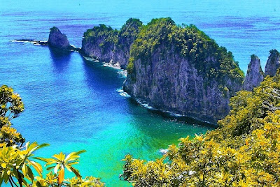
National Park of American Samoa

This card is also a first, the first from American Samoa, and it was also sent by Nancy. 

The National Park of American Samoa is a national park in the United States territory of American Samoa, distributed across three islands: Tutuila, Ofu, and Ta‘ū. This card is from Tatuila island and it shows Pola Island.
The park preserves and protects coral reefs, tropical rainforests, fruit bats, and the Samoan culture.


Pola Island is an island just offshore from the village of Vatia on Tutuila Island.The island is known for its high cliffs, populated by seabirds, and is one of American Samoa's primary seabird nesting sites.