Mail services never stop to susprise us and this card is a good example of that.
Last week I've received this card from Pakistan, written, sent and stamped on February 14th of.... 2020. 2020, not 2021! This isn't the only unique fact about it. Even though it was sent to my old address, I got it here, in the address I've been living for one year now. No, I don't have that mail forwarding service. I guess someone in the mail distribution center recognized my name et voilá, found this great card in my mailbox. I'm so glad it didn't get lost because it is from a missing UNESCO site.
The Archaeological Ruins at Moenjodaro are the best preserved urban settlement in South Asia dating back to the beginning of the 3rd millennium BC, and exercised a considerable influence on the subsequent development of urbanization.
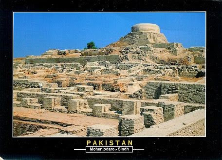
Foto Bank

The archaeological ruins are located on the right bank of the Indus River, 510 km north-east from Karachi, and 28 km from Larkana city, Larkana District in Pakistan’s Sindh Province. The property represents the metropolis of Indus civilization, which flourished between 2,500-1,500 BC in the Indus valley and is one of the world’s three great ancient civilizations.
The discovery of Moenjodaro in 1922 revealed evidence of the customs, art, religion and administrative abilities of its inhabitants. The well planned city mostly built with baked bricks and having public baths; a college of priests; an elaborate drainage system; wells, soak pits for disposal of sewage, and a large granary, bears testimony that it was a metropolis of great importance, enjoying a well organized civic, economic, social and cultural system.
Moenjodaro comprises two sectors: a citadel area in the west where the Buddhist stupa was constructed with unbaked brick over the ruins of Moenjodaro in the 2nd century AD, and to the east, the lower city ruins spread out along the banks of the Indus. Here buildings are laid out along streets intersecting each other at right angles, in a highly orderly form of city planning that also incorporated systems of sanitation and drainage. - in: https://whc.unesco.org/en/list/138


No comments:
Post a Comment